
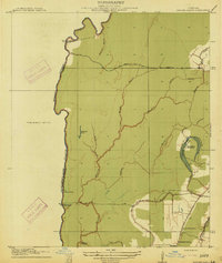
1914 Map of Baxter Bayou
USGS Topo · Published 1914About this map
Macon Bayou forms the winding western limit of this Louisiana delta landscape, marking the established boundary between West Carroll and East Carroll parishes. The interior is defined by a dense network of waterways, including the meandering Baxter Bayou, Buck Bayou, and Brushy Bayou, which drain the low-lying agricultural lands. Large landholdings like Tompkins Plantation, situated near the curved Cypress Brake, and Bowie Plantation reflect the area's deep-rooted plantation economy.
Find a feature on this map
24 named features on this map. Tap any name to fly to it.
Don’t see what you’re looking for? This feature index may not catch every label — zoom into the map to look around manually.
Map Details
Editions of this 1914 Baxter Bayou Map
2 editions found
Other maps of this area

1909 · Baxter Bayou
USGS Topo · 1:24,000

1909 · Lake Providence
USGS Topo · 1:24,000

1909 · Millikin
USGS Topo · 1:24,000

1909 · Ashton Bridge
USGS Topo · 1:24,000

1911 · Lake Providence
USGS Topo · 1:31,680

1911 · Baxter Bayou
USGS Topo · 1:24,000

1912 · Ashton Bridge
USGS Topo · 1:31,680

1935 · Oak Grove
USGS Topo · 1:62,500

1939 · Alsatia
USGS Topo · 1:62,500

1939 · Mayersville
USGS Topo · 1:62,500