1940s Maps of Jackson County, Mississippi
Explore 10 historic maps of Jackson County from the 1940s. These maps offer a rare glimpse into what life looked like during the 1940s — showing old roads, neighborhoods, homes, and landmarks that have changed or disappeared over time.
Whether you're researching your family's past, planning a metal detecting trip, or studying how Jackson County's landscape evolved across the 1940s, these high-resolution maps are a powerful tool for exploring the history of this region.
- Focus on a specific era: All maps on this page are from the 1940s, giving you a focused view of this time period.
- See what’s changed: Compare century-old streets, trails, and buildings to today's modern landscape using overlays and satellite layers.
- Research with precision: Use these maps for genealogy, historical research, land use analysis, or educational projects.
- View, download, or print: Maps are fully viewable online in high resolution, and can be downloaded or printed for your own records.
Start exploring Jackson County's history through authentic maps from the 1940s. This is your window into the past.
Jackson County, MS maps
(10)- 1941 Map of Hurley, 1953 Print
 1941 Hurley1953 Print · USGSThe borderlands between Mississippi and Alabama are captured here in the early 1940s as rural life centered on the river and rail. Local researchers can trace family landmarks and forgotten road networks from Hurley to St Elmo, including Tanners Cem, Baker Sch, and Slaughter Flat Landing.3 unique versions available
 - 1941 Map of Vancleave, 1959 Print
 1941 Vancleave1959 Print · USGSThe Pascagoula River bottomlands in the early 1940s reveal a landscape of oxbow lakes and timber-reliant settlements. Trace family roots at Wolf Ridge Cem, Graham Ferry, or the historic crossroads of Vancleave and Old Americus.4 unique versions available
 - 1941 Map of Horn Island, 1964 Print
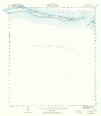 1941 Horn Island1964 Print · USGSThe barrier islands of Jackson County appear in their pre-war state during this early 1940s survey of the Gulf Coast. Marine researchers and local historians can trace the navigation routes through Horn Island Pass and the shifting Sand Dunes of Horn Island.
 - 1942 Map of Petit Bois Island
 1942 Petit Bois Island1942 Print · USGSCoastal barrier islands along the Alabama and Mississippi border appear in this wartime survey, showing the shifting sands before modern development. Maritime researchers can trace the navigational landscape of Petit Bois Pass and the position of the Horn Island L H.
 - 1942 Map of Horn Island
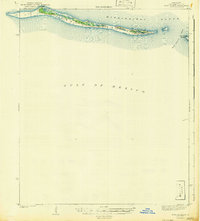 1942 Horn Island1942 Print · USGSThe barrier islands of the Mississippi coast are documented in detail here during the early forties. Researchers can trace the shifting shoreline of Horn Island and examine the coastal geography of Petit Bois Island and Horn Island Pass.
 - 1943 Map of Pascagoula
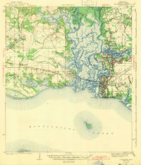 1943 Pascagoula1943 Print · USGSMississippi's Gulf Coast is shown during the early 1940s, highlighting the intricate delta where the Pascagoula River meets the sound. Genealogists and historians can trace the foundations of Moss Point and locate vanished rural landmarks like Zion Ch and Camp Lamotte.2 unique versions available
 - 1943 Map of Grand Bay
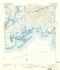 1943 Grand Bay1943 Print · USGSCoastal Alabama and Mississippi are captured here in the early 1940s, showing the vital rail-and-water networks of the Gulf. Genealogists and researchers can trace family lands near Bayou La Batre, the Orange Lake Sch, or the maritime settlement at Coden.2 unique versions available
 - 1943 Map of Hurley
 1943 Hurley1943 Print · USGSCoastal Mississippi and Alabama are surveyed here during the early war years, showing the rural communities between the rivers and the growing Gulf coast. Genealogists can locate family landmarks like Tanners Cem, Roberts Chapel, and the settlement of Nut Bank along the river bluffs.2 unique versions available
 - 1943 Map of Vancleave
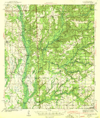
 1943 Vancleave1943 Print · USGSCoastal Mississippi river life in the early 1940s centers on the sprawling basin of the Pascagoula River. Researchers can trace family history through numerous rural landmarks like Wolf Ridge Cem, Old Americus, and the Campmeeting Ground.
 - 1944 Map of Vancleave
 1944 Vancleave1944 Print · USGSThe Pascagoula River valley during the early 1940s reveals a landscape of river landings, ferries, and scattered timber-country settlements. Genealogists can trace family locations near Graham Ferry, Old Americus, and Sins Mill Pond.2 unique versions available
End of results
Showing maps 1-10 of 10
Top cities of Jackson County
- Pascagoula historical maps
- Ocean Springs historical maps
- Gautier historical maps
- Moss Point historical maps
Frequently asked questions
- What are the different types of historical maps available for Jackson County?
- What is the oldest map of Jackson County?
- Where can I purchase historical maps of Jackson County for my home or office?
- Where can I download high-res historical maps of Jackson County?
- Are there historical topographic maps available for Jackson County?
- Is there historical aerial imagery available for Jackson County?
- Where are historical maps of Jackson County sourced from?