1960s Maps of Heidelberg, Mississippi
Explore 3 historic maps of Heidelberg from the 1960s. These maps offer a rare glimpse into what life looked like during the 1960s — showing old roads, neighborhoods, homes, and landmarks that have changed or disappeared over time.
Whether you're researching your family's past, planning a metal detecting trip, or studying how Heidelberg's landscape evolved across the 1960s, these high-resolution maps are a powerful tool for exploring the history of this region.
- Focus on a specific era: All maps on this page are from the 1960s, giving you a focused view of this time period.
- See what’s changed: Compare century-old streets, trails, and buildings to today's modern landscape using overlays and satellite layers.
- Research with precision: Use these maps for genealogy, historical research, land use analysis, or educational projects.
- View, download, or print: Maps are fully viewable online in high resolution, and can be downloaded or printed for your own records.
Start exploring Heidelberg's history through authentic maps from the 1960s. This is your window into the past.
Heidelberg, MS maps
(3)- 1963 Map of Waldrup, 1965 Print
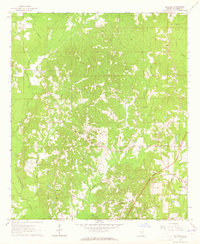 1963 Waldrup1965 Print · USGSJasper County's rural communities and church-centered social fabric are captured here in the early sixties. Genealogists can locate family landmarks like Oakbowery Ch, Pisgah Ch, and Old Ebenezer Ch along the waters of Tallahala Creek.3 unique versions available
 - 1963 Map of Heidelberg, 1965 Print
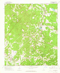 1963 Heidelberg1965 Print · USGSHeidelberg and the surrounding timberlands of Jasper and Clarke Counties are seen here in the early sixties as the rail-and-river economy matured. Trace family roots at Vossburg, Stafford Springs, and numerous local sites like Eddins Memorial Cem.2 unique versions available
 - 1964 Map of Heidelberg SW, 1965 Print
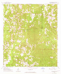 1964 Heidelberg SW1965 Print · USGSFour Mississippi counties meet among the creek bottoms and timberlands south of Heidelberg in the mid-sixties. Genealogists can trace rural family sites like Blackledge Cem, Bogue Homo Sch, and the Old Indian Treaty Boundary.3 unique versions available
End of results
Showing maps 1-3 of 3
Top cities near Heidelberg
Frequently asked questions
- What are the different types of historical maps available for Heidelberg?
- What is the oldest map of Heidelberg?
- Where can I purchase historical maps of Heidelberg for my home or office?
- Where can I download high-res historical maps of Heidelberg?
- Are there historical topographic maps available for Heidelberg?
- Is there historical aerial imagery available for Heidelberg?
- Where are historical maps of Heidelberg sourced from?