1970s Maps of Montrose, Mississippi
Explore 2 historic maps of Montrose from the 1970s. These maps offer a rare glimpse into what life looked like during the 1970s — showing old roads, neighborhoods, homes, and landmarks that have changed or disappeared over time.
Whether you're researching your family's past, planning a metal detecting trip, or studying how Montrose's landscape evolved across the 1970s, these high-resolution maps are a powerful tool for exploring the history of this region.
- Focus on a specific era: All maps on this page are from the 1970s, giving you a focused view of this time period.
- See what’s changed: Compare century-old streets, trails, and buildings to today's modern landscape using overlays and satellite layers.
- Research with precision: Use these maps for genealogy, historical research, land use analysis, or educational projects.
- View, download, or print: Maps are fully viewable online in high resolution, and can be downloaded or printed for your own records.
Start exploring Montrose's history through authentic maps from the 1970s. This is your window into the past.
Montrose, MS maps
(2)- 1970 Map of Montrose North, 1972 Print
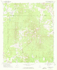 1970 Montrose North1972 Print · USGSJasper and Newton counties in the early 1970s remained a region of timbered hills and quiet railroad junctions. Researchers can trace the Gulf Mobile and Ohio line past Garlandville or locate family sites at Sand Ridge Church and the Pilgrim Rest Ch Cemeteries.2 unique versions available
 - 1970 Map of Montrose South, 1972 Print
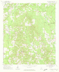 1970 Montrose South1972 Print · USGSJasper County in the early seventies shows a rural landscape of timberland and creekside settlements just before modern development. Genealogists can trace family footprints through numerous sites like St Paul Cem, McNeal, and the Antioch Cem.
End of results
Showing maps 1-2 of 2
Top cities near Montrose
- Forest historical maps
- Newton historical maps
- Bay Springs historical maps
- Heidelberg historical maps
- Hickory historical maps
- Louin historical maps
See more
Frequently asked questions
- What are the different types of historical maps available for Montrose?
- What is the oldest map of Montrose?
- Where can I purchase historical maps of Montrose for my home or office?
- Where can I download high-res historical maps of Montrose?
- Are there historical topographic maps available for Montrose?
- Is there historical aerial imagery available for Montrose?
- Where are historical maps of Montrose sourced from?