1960s Maps of Lowndes County, Mississippi
Explore 4 historic maps of Lowndes County from the 1960s. These maps offer a rare glimpse into what life looked like during the 1960s — showing old roads, neighborhoods, homes, and landmarks that have changed or disappeared over time.
Whether you're researching your family's past, planning a metal detecting trip, or studying how Lowndes County's landscape evolved across the 1960s, these high-resolution maps are a powerful tool for exploring the history of this region.
- Focus on a specific era: All maps on this page are from the 1960s, giving you a focused view of this time period.
- See what’s changed: Compare century-old streets, trails, and buildings to today's modern landscape using overlays and satellite layers.
- Research with precision: Use these maps for genealogy, historical research, land use analysis, or educational projects.
- View, download, or print: Maps are fully viewable online in high resolution, and can be downloaded or printed for your own records.
Start exploring Lowndes County's history through authentic maps from the 1960s. This is your window into the past.
Lowndes County, MS maps
(4)- 1960 Map of Caledonia, 1961 Print
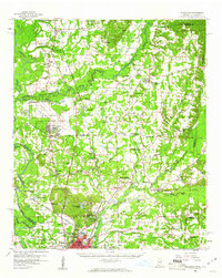 1960 Caledonia1961 Print · USGSThe Mississippi-Alabama borderlands in the early sixties reveal a landscape of growing military bases and traditional river commerce. Trace family roots through rural landmarks like Anderson Grove Sch, Waverly Ferry, and the rail lines serving Steens.2 unique versions available
 - 1960 Map of Columbus, 1961 Print
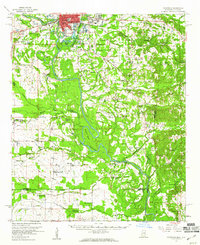 1960 Columbus1961 Print · USGSThe Tombigbee River valley at the start of the 1960s shows a landscape of river-bend farms and rural communities centered around family churches and schools. Researchers can trace historic river crossings like the Nashville Ferry or locate ancestral sites at St Mathis Cem and Plum Grove Sch.2 unique versions available
 - 1963 Map of West Point
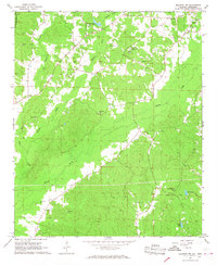
 1963 West Point1963 Print · USGSEastern Mississippi and western Alabama are captured in the early sixties as industrial centers and rail lines connected the Black Prairie to the hills. Genealogists and historians can trace family-named watercourses and the early footprints of Starkville, Columbus, and the Noxubee National Wildlife Refuge.2 unique versions available
 - 1967 Map of Millport NW, 1968 Print
 1967 Millport NW1968 Print · USGSLamar County in the late 1960s was a rural landscape defined by tight-knit communities and winding creek valleys. Researchers can locate family landmarks like Lampkin Cem and Sailor Cem, or trace local history at the Lamar County Training Sch.3 unique versions available
End of results
Showing maps 1-4 of 4
Top cities of Lowndes County
Frequently asked questions
- What are the different types of historical maps available for Lowndes County?
- What is the oldest map of Lowndes County?
- Where can I purchase historical maps of Lowndes County for my home or office?
- Where can I download high-res historical maps of Lowndes County?
- Are there historical topographic maps available for Lowndes County?
- Is there historical aerial imagery available for Lowndes County?
- Where are historical maps of Lowndes County sourced from?