
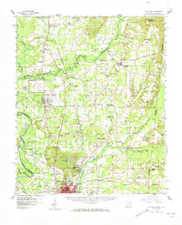
1960 Map of Caledonia
USGS Topo · Published 1961About this map
Columbus Air Force Base dominates the central landscape of this 1960 survey, illustrating the significant military footprint in Lowndes County during the Cold War. The surrounding territory is defined by the winding courses of the Tombigbee River and the Buttahatchie River, creating a complex network of sloughs and creeks like Luxapalila Creek and Running Slough Branch. A high concentration of rural institutions points to a deeply rooted community structure, evidenced by numerous country churches such as Border Springs Ch and Military Chapel, alongside schools like Anderson Grove Sch and Hardy Bluff Sch.
Find a feature on this map
90 named features on this map. Tap any name to fly to it.
Don’t see what you’re looking for? This feature index may not catch every label — zoom into the map to look around manually.
Map Details
Editions of this 1960 Caledonia Map
2 editions found
Other maps of this area

1953 · West Point
USGS Topo · 1:250,000

1958 · West Point
USGS Topo · 1:250,000

1959 · Artesia
USGS Topo · 1:62,500

1959 · West Point
USGS Topo · 1:62,500

1960 · Columbus
USGS Topo · 1:62,500

1963 · West Point
USGS Topo · 1:250,000

1966 · Aberdeen
USGS Topo · 1:24,000

1966 · Amory SW
USGS Topo · 1:24,000

1966 · Amory SE
USGS Topo · 1:24,000

1966 · Ethelsville
USGS Topo · 1:24,000