1980s Maps of Canton, Mississippi
Explore 6 historic maps of Canton from the 1980s. These maps offer a rare glimpse into what life looked like during the 1980s — showing old roads, neighborhoods, homes, and landmarks that have changed or disappeared over time.
Whether you're researching your family's past, planning a metal detecting trip, or studying how Canton's landscape evolved across the 1980s, these high-resolution maps are a powerful tool for exploring the history of this region.
- Focus on a specific era: All maps on this page are from the 1980s, giving you a focused view of this time period.
- See what’s changed: Compare century-old streets, trails, and buildings to today's modern landscape using overlays and satellite layers.
- Research with precision: Use these maps for genealogy, historical research, land use analysis, or educational projects.
- View, download, or print: Maps are fully viewable online in high resolution, and can be downloaded or printed for your own records.
Start exploring Canton's history through authentic maps from the 1980s. This is your window into the past.
Canton, MS maps
(6)- 1984 Map of Yazoo City
 1984 Yazoo City1984 Print · USGSThe Mississippi Delta and loess bluffs meet in the mid-eighties as the Yazoo River snakes through a dense network of wildlife areas and rail lines. Researchers can trace rural life and drainage history through small communities like Holly Bluff, Mechanicsburg, and Satartia.2 unique versions available
 - 1984 Map of Carthage
 1984 Carthage1984 Print · USGSLeake and Neshoba counties in the mid-1980s showcase a transition from the Government Hills to the dense Bienville National Forest. Genealogists and researchers can trace the historic Natchez Trace Parkway and local settlements like Plattsburg and Williamsville.
 - 1988 Map of Sharon, 1989 Print
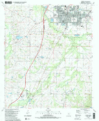
 1988 Sharon1989 Print · USGSThe community of Sharon and its surrounding Madison County farmland are captured here in the late 1980s. Genealogists can trace family footprints through numerous local landmarks like Sims Chapel, St Mark Ch, and Hassley Herron Lake.
 - 1989 Map of Shoccoe
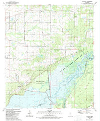 1989 Shoccoe1989 Print · USGSThe Pearl River bottomlands and the reservoir shoreline come into focus in the late eighties as conservation areas expand. Local historians can trace old community landmarks like Zion Chapel, the Old Railroad Grade, and Madisonville along the historic Natchez Trace Parkway.
 - 1989 Map of Way
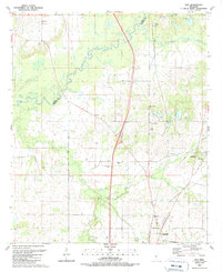 1989 Way1989 Print · USGSMississippi's river borderlands appear in detail in the late 1980s, centered on the Big Black River. Genealogists can trace family burial sites like Knott Cem and rural centers including Cobbville, Way, and Thornton Chapel.
 - 1989 Map of Canton
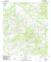
 1989 Canton1989 Print · USGSMadison County's central landscape is captured here in the late eighties, showing a community defined by its schools and rural parishes. Genealogists can trace family names at Harvey Chapel, Old Madison Ch and Sch, and the Mt Able Cem.
End of results
Showing maps 1-6 of 6
Top cities near Canton
- Jackson historical maps
- Madison historical maps
- Ridgeland historical maps
- Flowood historical maps
- Gluckstadt historical maps
Top neighborhoods of Canton
Frequently asked questions
- What are the different types of historical maps available for Canton?
- What is the oldest map of Canton?
- Where can I purchase historical maps of Canton for my home or office?
- Where can I download high-res historical maps of Canton?
- Are there historical topographic maps available for Canton?
- Is there historical aerial imagery available for Canton?
- Where are historical maps of Canton sourced from?