1960s Maps of Hudsonville, Mississippi
Explore 2 historic maps of Hudsonville from the 1960s. These maps offer a rare glimpse into what life looked like during the 1960s — showing old roads, neighborhoods, homes, and landmarks that have changed or disappeared over time.
Whether you're researching your family's past, planning a metal detecting trip, or studying how Hudsonville's landscape evolved across the 1960s, these high-resolution maps are a powerful tool for exploring the history of this region.
- Focus on a specific era: All maps on this page are from the 1960s, giving you a focused view of this time period.
- See what’s changed: Compare century-old streets, trails, and buildings to today's modern landscape using overlays and satellite layers.
- Research with precision: Use these maps for genealogy, historical research, land use analysis, or educational projects.
- View, download, or print: Maps are fully viewable online in high resolution, and can be downloaded or printed for your own records.
Start exploring Hudsonville's history through authentic maps from the 1960s. This is your window into the past.
Hudsonville, MS maps
(2)- 1965 Map of Holly Springs, 1966 Print
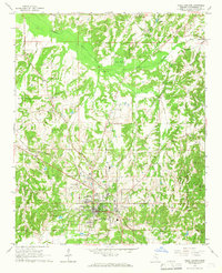 1965 Holly Springs1966 Print · USGSHolly Springs was a prominent hub of education and rail at the height of the mid-sixties. Genealogists and historians can trace family landmarks like Hillcrest Cem, McAlexander Cem, and the grounds of Mississippi Industrial College.2 unique versions available
 - 1969 Map of Holly Springs
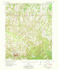 1969 Holly Springs1969 Print · USGSNorthern Mississippi and the Tennessee borderlands are detailed here in the late sixties, centered on the rail crossroads of Holly Springs. Genealogists and local historians can trace hundreds of rural landmarks, including Early Grove Cem, Roberts Chapel, and the Sand Flats Jr High Sch.
End of results
Showing maps 1-2 of 2
Top cities near Hudsonville
- Holly Springs historical maps
- Piperton historical maps
- Ashland historical maps
- Moscow historical maps
- Potts Camp historical maps
- Rossville historical maps
See more
Frequently asked questions
- What are the different types of historical maps available for Hudsonville?
- What is the oldest map of Hudsonville?
- Where can I purchase historical maps of Hudsonville for my home or office?
- Where can I download high-res historical maps of Hudsonville?
- Are there historical topographic maps available for Hudsonville?
- Is there historical aerial imagery available for Hudsonville?
- Where are historical maps of Hudsonville sourced from?