1990s Maps of Pearl River County, Mississippi
Explore 8 historic maps of Pearl River County from the 1990s. These maps offer a rare glimpse into what life looked like during the 1990s — showing old roads, neighborhoods, homes, and landmarks that have changed or disappeared over time.
Whether you're researching your family's past, planning a metal detecting trip, or studying how Pearl River County's landscape evolved across the 1990s, these high-resolution maps are a powerful tool for exploring the history of this region.
- Focus on a specific era: All maps on this page are from the 1990s, giving you a focused view of this time period.
- See what’s changed: Compare century-old streets, trails, and buildings to today's modern landscape using overlays and satellite layers.
- Research with precision: Use these maps for genealogy, historical research, land use analysis, or educational projects.
- View, download, or print: Maps are fully viewable online in high resolution, and can be downloaded or printed for your own records.
Start exploring Pearl River County's history through authentic maps from the 1990s. This is your window into the past.
Pearl River County, MS maps
(8)- 1993 Map of Nicholson, 1995 Print
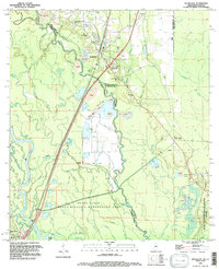 1993 Nicholson1995 Print · USGSNicholson and the surrounding river lowlands are captured here in the early nineties as the NASA buffer zone meets the Pearl River basin. Genealogists can locate family sites like Old Palestine Ch, Cedar Grove Cem, and Corinth Ch among the many bayous.
 - 1994 Map of Bogalusa
 1994 Bogalusa1994 Print · USGSThe timber country and river bottoms of the Louisiana-Mississippi borderlands come alive in the mid-nineties. Genealogists and researchers can trace the rail-and-river geography of Bogalusa, the winding Pearl River, and family settlements like McNeill and Varnado.2 unique versions available
 - 1994 Map of Hattiesburg, 1995 Print
 1994 Hattiesburg1995 Print · USGSSouth-central Mississippi's river valleys and timberlands are seen here in the mid-1990s as the region's transport network matured. Researchers can trace rural lineages through sites like Old Pioneer Cem and Spring Cottage or explore the vast Camp Shelby Military Reservation.
 - 1997 Map of Industrial, 1999 Print
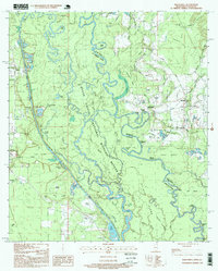 1997 Industrial1999 Print · USGSThe Pearl River bottomlands at the Mississippi-Louisiana line appear here in the late nineties as a complex maze of bayous and islands. Researchers can locate family burial sites like Carpenter Cem and Parker Cem or trace the early paths of Stewart Road and Walkiah Road.
 - 1997 Map of Picayune, 1999 Print
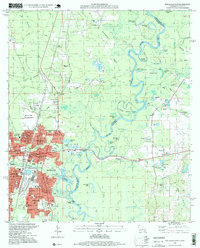
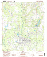 1997 Picayune1999 Print · USGSPicayune and the surrounding Pearl River County pine woods are captured here during a period of steady growth in the late nineties. Local researchers can trace the development of Carriere and Ozona, or locate landmarks like Hide-A-Way Lake and the Municipal Airport.
 - 1997 Map of Bogalusa East, 1999 Print
 1997 Bogalusa East1999 Print · USGSBogalusa and the Pearl River corridor are shown late in the twentieth century, bridging the Louisiana-Mississippi border. Genealogists and historians can locate numerous family-named sites, including Miley Cem, Piggott Crossing, and the Sullivan Voc-Tech Inst.
 - 1998 Map of Hickory, 1999 Print
 1998 Hickory1999 Print · USGSThe river bottomlands of St. Tammany Parish are captured here at the end of the century, centered on the community of Hickory. Genealogists and local historians can locate legacy family landmarks such as Smith Cem, Moran Cem, and the Charter Oak Ch.
 - 1998 Map of Nicholson, 2000 Print
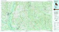
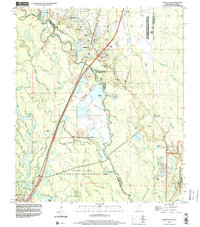 1998 Nicholson2000 Print · USGSThe Pearl River delta comes into focus in the late nineties as a landscape of industrial gravel pits and aerospace boundaries. Genealogists and researchers can trace family sites like Cedar Grove Cem and Santa Rosa or locate landmarks like Jackson Landing.2 unique versions available
End of results
Showing maps 1-8 of 8
Top cities of Pearl River County
Frequently asked questions
- What are the different types of historical maps available for Pearl River County?
- What is the oldest map of Pearl River County?
- Where can I purchase historical maps of Pearl River County for my home or office?
- Where can I download high-res historical maps of Pearl River County?
- Are there historical topographic maps available for Pearl River County?
- Is there historical aerial imagery available for Pearl River County?
- Where are historical maps of Pearl River County sourced from?