1970s Maps of Pike County, Mississippi
Explore 9 historic maps of Pike County from the 1970s. These maps offer a rare glimpse into what life looked like during the 1970s — showing old roads, neighborhoods, homes, and landmarks that have changed or disappeared over time.
Whether you're researching your family's past, planning a metal detecting trip, or studying how Pike County's landscape evolved across the 1970s, these high-resolution maps are a powerful tool for exploring the history of this region.
- Focus on a specific era: All maps on this page are from the 1970s, giving you a focused view of this time period.
- See what’s changed: Compare century-old streets, trails, and buildings to today's modern landscape using overlays and satellite layers.
- Research with precision: Use these maps for genealogy, historical research, land use analysis, or educational projects.
- View, download, or print: Maps are fully viewable online in high resolution, and can be downloaded or printed for your own records.
Start exploring Pike County's history through authentic maps from the 1970s. This is your window into the past.
Pike County, MS maps
(9)- 1972 Map of Osyka, 1974 Print
 1972 Osyka1974 Print · USGSCrossing the Mississippi-Louisiana border in the early seventies, this area centers on the rail-driven growth of Osyka and the spiritual hub of Chatawa. Researchers can trace local lineage at St Mary of the Pines Academy or through family sites like Dickey Cem and Varnado Cem.
 - 1972 Map of Auburn, 1974 Print
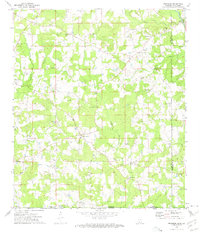
 1972 Auburn1974 Print · USGSAmite and Lincoln Counties come into focus in the early seventies as the local oil industry expands across the landscape. Genealogists can trace family roots through numerous country sites like Johnston Chapel, Terrell Cem, and the Smithdale Oil Field.
 - 1972 Map of Pricedale, 1974 Print
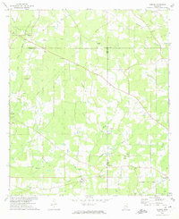
 1972 Pricedale1974 Print · USGSPike and Lincoln Counties are captured in the early seventies, showcasing a rural landscape defined by oil production and creek-side settlements. Genealogists can locate family-named landmarks like McDavid Cem and McEwen Cem or local centers like Pricedale and Felders Campground.
 - 1972 Map of McComb South, 1974 Print
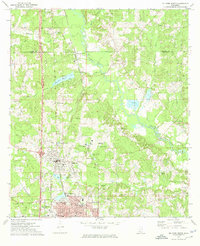
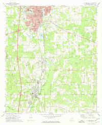 1972 McComb South1974 Print · USGSPike County comes to life in the early seventies, showing the industrial and civic growth of McComb and Magnolia. Researchers can trace family roots at Hollywood Cem or locate old school sites like Alpha Center Sch and Kirkville.
 - 1972 Map of Lake Tangipahoa, 1974 Print
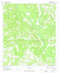
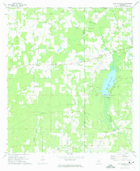 1972 Lake Tangipahoa1974 Print · USGSSouthwest Mississippi during the early seventies is defined here by the waters of Lake Tangipahoa and the busy Mc Comb Oil Field. Genealogists and historians can trace rural family landmarks like Rose Bower Church, Pikemite Cemetery, and the Old Railroad Grade.
 - 1972 Map of Holmesville, 1974 Print
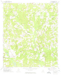
 1972 Holmesville1974 Print · USGSPike and Walthall Counties come alive in this early 1970s survey of the Bogue Chitto river valley. Researchers can trace rural lineages through the numerous family cemeteries and churches, including Holmesville Cem, Pink Hill Ch, and Webb Cem.
 - 1972 Map of McComb North, 1974 Print
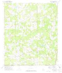
 1972 McComb North1974 Print · USGSThe Pike County corridor in the early seventies shows the steady growth of Summit and Mc Comb along the Illinois Central Gulf rail line. Researchers can trace local roots at Johnstons Station or locate family plots in Woodlawn Cem and Rocky Point Cem.
 - 1972 Map of Progress, 1975 Print
 1972 Progress1975 Print · USGSSouthern Mississippi at the turn of the 1970s reveals a landscape of family farms and creek-side settlements. Genealogists can locate family landmarks like Brumfield Cem and Walker Cem or the Bala Chitto Ch near the Louisiana state line.2 unique versions available
 - 1972 Map of Terrys Creek, 1975 Print
 1972 Terrys Creek1975 Print · USGSThe Mississippi-Louisiana borderlands in the early seventies reveal a rural landscape defined by the Tickfaw River and local industry. Genealogists and historians can trace the Gillsburg Oil Field, family-named landmarks like Roberts Cem, and the Terrys Creek Ch.
End of results
Showing maps 1-9 of 9
Top cities of Pike County
Frequently asked questions
- What are the different types of historical maps available for Pike County?
- What is the oldest map of Pike County?
- Where can I purchase historical maps of Pike County for my home or office?
- Where can I download high-res historical maps of Pike County?
- Are there historical topographic maps available for Pike County?
- Is there historical aerial imagery available for Pike County?
- Where are historical maps of Pike County sourced from?