1980s Maps of Pike County, Mississippi
Explore 4 historic maps of Pike County from the 1980s. These maps offer a rare glimpse into what life looked like during the 1980s — showing old roads, neighborhoods, homes, and landmarks that have changed or disappeared over time.
Whether you're researching your family's past, planning a metal detecting trip, or studying how Pike County's landscape evolved across the 1980s, these high-resolution maps are a powerful tool for exploring the history of this region.
- Focus on a specific era: All maps on this page are from the 1980s, giving you a focused view of this time period.
- See what’s changed: Compare century-old streets, trails, and buildings to today's modern landscape using overlays and satellite layers.
- Research with precision: Use these maps for genealogy, historical research, land use analysis, or educational projects.
- View, download, or print: Maps are fully viewable online in high resolution, and can be downloaded or printed for your own records.
Start exploring Pike County's history through authentic maps from the 1980s. This is your window into the past.
Pike County, MS maps
(4)- 1980 Map of Kentwood, 1981 Print
 1980 Kentwood1981 Print · USGSKentwood and Tangipahoa appear during the early 1980s as the railroad and timber landscape of the Louisiana-Mississippi line remains firmly established. Researchers can find dozens of family burial sites like Westmoreland Cem and the Camp Moore Confederate Cem.2 unique versions available
 - 1983 Map of Amite
 1983 Amite1983 Print · USGSThe Florida Parishes and southern Mississippi are captured here in the early 1980s, centered on the Illinois Central Gulf rail corridor. Genealogists and historians can trace family-named sites like the Camp Moore Confederate Cem, Magnolia Ch, and the Idlewild Plantation (State University).
 - 1983 Map of Spring Creek, 1984 Print
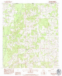 1983 Spring Creek1984 Print · USGSThe Louisiana-Mississippi border comes into focus in the early eighties as a network of creek-side settlements and family homesteads. Genealogists can trace local lineages at Masonic Cem and Conerly Cem or locate the site of Hagen Sch.
 - 1984 Map of McComb
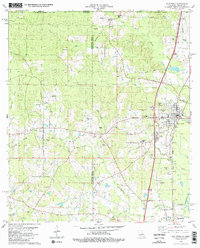
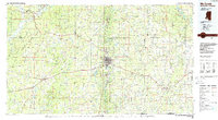 1984 McComb1984 Print · USGSSouth Mississippi in the mid-eighties was defined by the rail corridor connecting McComb and Magnolia to the surrounding timberlands. You can trace the rural network of Pike County through landmarks like Holmesville, Percy Quin State Park, and the winding Bogue Chitto.
End of results
Showing maps 1-4 of 4
Top cities of Pike County
Frequently asked questions
- What are the different types of historical maps available for Pike County?
- What is the oldest map of Pike County?
- Where can I purchase historical maps of Pike County for my home or office?
- Where can I download high-res historical maps of Pike County?
- Are there historical topographic maps available for Pike County?
- Is there historical aerial imagery available for Pike County?
- Where are historical maps of Pike County sourced from?