1980s Maps of Pontotoc County, Mississippi
Explore 10 historic maps of Pontotoc County from the 1980s. These maps offer a rare glimpse into what life looked like during the 1980s — showing old roads, neighborhoods, homes, and landmarks that have changed or disappeared over time.
Whether you're researching your family's past, planning a metal detecting trip, or studying how Pontotoc County's landscape evolved across the 1980s, these high-resolution maps are a powerful tool for exploring the history of this region.
- Focus on a specific era: All maps on this page are from the 1980s, giving you a focused view of this time period.
- See what’s changed: Compare century-old streets, trails, and buildings to today's modern landscape using overlays and satellite layers.
- Research with precision: Use these maps for genealogy, historical research, land use analysis, or educational projects.
- View, download, or print: Maps are fully viewable online in high resolution, and can be downloaded or printed for your own records.
Start exploring Pontotoc County's history through authentic maps from the 1980s. This is your window into the past.
Pontotoc County, MS maps
(10)- 1980 Map of Northwest Pontotoc, 1981 Print
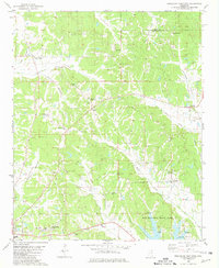
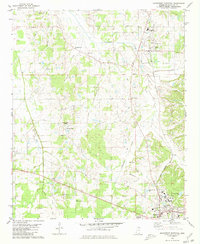 1980 Northwest Pontotoc1981 Print · USGSPontotoc and Ecru are captured here in the mid-1970s as agricultural traditions met modernizing infrastructure. Local researchers can trace family roots through sites like Weatherall Cem, Wardlow Cem, and the town center of Ecru.
 - 1980 Map of Thaxton, 1981 Print
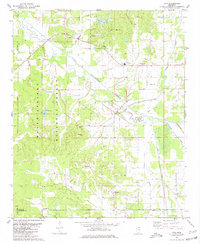
 1980 Thaxton1981 Print · USGSNortheast Mississippi during the late seventies reveals a landscape of small agricultural hubs and national forest land. Researchers can pinpoint rural congregations and family cemeteries like Sand Spring Ch, Bellvue Ch, and Laodicea Cem.
 - 1980 Map of New Albany West, 1981 Print
 1980 New Albany West1981 Print · USGSUnion County during the early eighties showcases a landscape defined by the intersection of three major railroads and the waters of the Little Tallahatchie River. Trace family history through rural sites like Ingomar, the Union Hill Cem, and numerous country churches including Zion Chapel.
 - 1980 Map of New Albany East, 1981 Print
 1980 New Albany East1981 Print · USGSNortheast Mississippi in the early eighties shows a landscape of rail-connected towns and rural hill country. You can trace the St Louis-San Francisco rail line through Wallerville or locate family markers at Oak Grove Ch Cem and Adair Cem.
 - 1980 Map of Northeast Pontotoc, 1981 Print
 1980 Northeast Pontotoc1981 Print · USGSNortheast Mississippi in the 1980s reveals a rural landscape defined by historic creek bottoms and dispersed settlements. Genealogists and historians can trace family locations near Poplar Springs, Cherry Creek, and Spring Hill Cem while locating the route of the Old Natchez Trace Park.
 - 1980 Map of Etta, 1981 Print
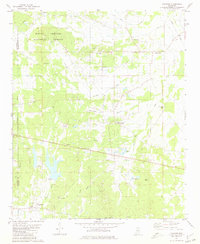
 1980 Etta1981 Print · USGSNortheast Mississippi’s river bottoms and timberlands are well-preserved here in the early eighties, just as modern infrastructure began to weave through the forest. Genealogists can trace family footprints through numerous rural landmarks like West Union Sch, Salem Ch, and Friendship Cem.
 - 1980 Map of Sherman, 1981 Print
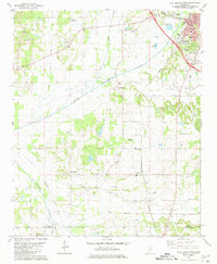
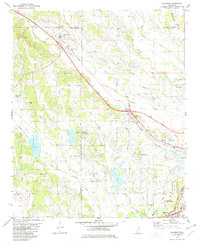 1980 Sherman1981 Print · USGSAs the Tupelo area expanded in the early eighties, this survey captures the rural character of the Lee, Union, and Pontotoc county lines. Genealogists and local historians can trace family plots at Union Cem or follow the old St Louis-San Francisco rail line through Sherman and Belden.
 - 1984 Map of Tupelo
 1984 Tupelo1984 Print · USGSNorth Mississippi in the 1980s is defined by its massive river basin reservoirs and the growing regional hubs of Tupelo and Oxford. Researchers can trace the legacy of the Pontotoc Ridge, find the University of Mississippi, and map early Interstate corridors near Sardis Lake.3 unique versions available
 - 1984 Map of Tupelo, 1985 Print
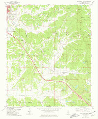
 1984 Tupelo1985 Print · USGSNortheast Mississippi and the Alabama borderlands are shown in the mid-1980s as timber and river networks shaped the region. Trace local history through the Illinois Central Gulf rail line and sites like the Old Natchez Trace Parkway.
 - 1984 Map of Oxford, 1985 Print
 1984 Oxford1985 Print · USGSOxford and its surrounding hill country are captured in the mid-eighties as university life and rural industry intersected. Genealogists and historians can trace rail lines like the ST LOUIS-SAN FRANCISCO RY and locate old rural centers such as College Hill Sta and Lafayette Springs.
End of results
Showing maps 1-10 of 10
Top cities of Pontotoc County
- Pontotoc historical maps
- Ecru historical maps
- Algoma historical maps
- Thaxton historical maps
- Toccopola historical maps
Frequently asked questions
- What are the different types of historical maps available for Pontotoc County?
- What is the oldest map of Pontotoc County?
- Where can I purchase historical maps of Pontotoc County for my home or office?
- Where can I download high-res historical maps of Pontotoc County?
- Are there historical topographic maps available for Pontotoc County?
- Is there historical aerial imagery available for Pontotoc County?
- Where are historical maps of Pontotoc County sourced from?