1980s Maps of Harbert Landing, Mississippi
Explore 2 historic maps of Harbert Landing from the 1980s. These maps offer a rare glimpse into what life looked like during the 1980s — showing old roads, neighborhoods, homes, and landmarks that have changed or disappeared over time.
Whether you're researching your family's past, planning a metal detecting trip, or studying how Harbert Landing's landscape evolved across the 1980s, these high-resolution maps are a powerful tool for exploring the history of this region.
- Focus on a specific era: All maps on this page are from the 1980s, giving you a focused view of this time period.
- See what’s changed: Compare century-old streets, trails, and buildings to today's modern landscape using overlays and satellite layers.
- Research with precision: Use these maps for genealogy, historical research, land use analysis, or educational projects.
- View, download, or print: Maps are fully viewable online in high resolution, and can be downloaded or printed for your own records.
Start exploring Harbert Landing's history through authentic maps from the 1980s. This is your window into the past.
Harbert Landing, MS maps
(2)- 1982 Map of Stubbs Island
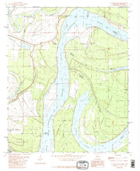 1982 Stubbs Island1982 Print · USGSThe Mississippi River Delta at the start of the 1980s reveals a complex world of shifting watercourses and state boundaries. Trace the remnants of the old river channel through Hardin Cut-off, the waters of Laddie Lake, and the isolated reaches of Stubbs Island.2 unique versions available
 - 1984 Map of Helena, 1985 Print
 1984 Helena1985 Print · USGSThe Delta landscape of Arkansas and Mississippi comes to life in this mid-eighties survey of river bends and ridge settlements. Researchers can trace the rail-and-river economy through Missouri Pacific lines and local landmarks like Whiskey Island or Marianna.
End of results
Showing maps 1-2 of 2
Top cities near Harbert Landing
- Helena-West Helena historical maps
- Marianna historical maps
- Tunica historical maps
- Lula historical maps
- Lexa historical maps
- La Grange historical maps
See more
Frequently asked questions
- What are the different types of historical maps available for Harbert Landing?
- What is the oldest map of Harbert Landing?
- Where can I purchase historical maps of Harbert Landing for my home or office?
- Where can I download high-res historical maps of Harbert Landing?
- Are there historical topographic maps available for Harbert Landing?
- Is there historical aerial imagery available for Harbert Landing?
- Where are historical maps of Harbert Landing sourced from?