1980s Maps of North Haven, Mississippi
Explore 3 historic maps of North Haven from the 1980s. These maps offer a rare glimpse into what life looked like during the 1980s — showing old roads, neighborhoods, homes, and landmarks that have changed or disappeared over time.
Whether you're researching your family's past, planning a metal detecting trip, or studying how North Haven's landscape evolved across the 1980s, these high-resolution maps are a powerful tool for exploring the history of this region.
- Focus on a specific era: All maps on this page are from the 1980s, giving you a focused view of this time period.
- See what’s changed: Compare century-old streets, trails, and buildings to today's modern landscape using overlays and satellite layers.
- Research with precision: Use these maps for genealogy, historical research, land use analysis, or educational projects.
- View, download, or print: Maps are fully viewable online in high resolution, and can be downloaded or printed for your own records.
Start exploring North Haven's history through authentic maps from the 1980s. This is your window into the past.
North Haven, MS maps
(3)- 1982 Map of Keownville, 1983 Print
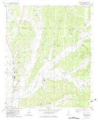 1982 Keownville1983 Print · USGSNortheast Mississippi at the start of the eighties shows a landscape of creek-fed valleys and quiet rail junctions. Genealogists can locate family landmarks like Roach Cem, Keownville, and several country churches including Ebenezer Ch and Palestine Ch.
 - 1984 Map of Corinth
 1984 Corinth1984 Print · USGSNortheast Mississippi and its borders with Alabama and Tennessee are captured here in the mid-1980s, showcasing a landscape of rail-connected towns and ridge-top settlements. Researchers can trace the path of the Natchez Trace Parkway or locate family-named landmarks near Biggersville, Kossuth, and the historic Tennessee Divide.
 - 1984 Map of Tupelo
 1984 Tupelo1984 Print · USGSNorth Mississippi in the 1980s is defined by its massive river basin reservoirs and the growing regional hubs of Tupelo and Oxford. Researchers can trace the legacy of the Pontotoc Ridge, find the University of Mississippi, and map early Interstate corridors near Sardis Lake.3 unique versions available
End of results
Showing maps 1-3 of 3
Top cities near North Haven
- Tupelo historical maps
- New Albany historical maps
- Ripley historical maps
- Ecru historical maps
- Blue Mountain historical maps
- Thaxton historical maps
See more
Frequently asked questions
- What are the different types of historical maps available for North Haven?
- What is the oldest map of North Haven?
- Where can I purchase historical maps of North Haven for my home or office?
- Where can I download high-res historical maps of North Haven?
- Are there historical topographic maps available for North Haven?
- Is there historical aerial imagery available for North Haven?
- Where are historical maps of North Haven sourced from?