Old Maps of Wayne County, Mississippi for Metal Detecting
Plan your next treasure hunt with 139 historic maps of Wayne County. Find old homesites, ghost towns, trails, and gathering spots that may be lost to time — perfect for identifying promising metal detecting locations.
- Locate forgotten sites: Uncover places like long-lost settlements, abandoned rail lines, or gathering spots.
- Plan better hunts: Use map overlays combined with LiDAR or satellite views to narrow in on historically rich areas.
- Made for detectorists: Thousands of hobbyists use these maps to discover relics, coins, and hidden history.
Use these historic maps to boost your research and find new opportunities beneath the surface of Wayne County.
Wayne County, MS maps
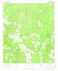
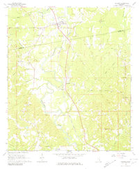
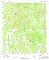
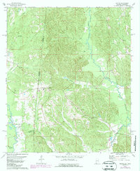
(139)- 1953 Map of Hattiesburg, 1965 Print
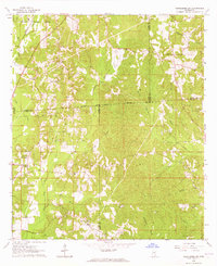
 1953 Hattiesburg1965 Print · USGSSouth Mississippi and western Alabama are shown here during the mid-twentieth century as the timber and rail industries shaped the region. Genealogists and historians can trace rail lines like the Mississippi Central and locate rural centers such as Magee, Richton, and Mount Vernon.4 unique versions available
 - 1958 Map of Hattiesburg
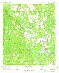
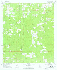
 1958 Hattiesburg1958 Print · USGSSoutheastern Mississippi's timber and rail networks are at their peak during the late fifties, centered on the growing hubs of Hattiesburg and Laurel. Researchers can trace old family landmarks like Sims Chapel, the Busbey Game Refuge, and the vanished stops along the Mississippi Central railroad.2 unique versions available
 - 1964 Map of Heidelberg SW, 1965 Print
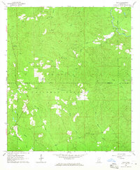
 1964 Heidelberg SW1965 Print · USGSFour Mississippi counties meet among the creek bottoms and timberlands south of Heidelberg in the mid-sixties. Genealogists can trace rural family sites like Blackledge Cem, Bogue Homo Sch, and the Old Indian Treaty Boundary.3 unique versions available
 - 1964 Map of Carmichael, 1965 Print
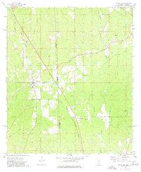
 1964 Carmichael1965 Print · USGSIn the mid-1960s, Clarke County saw a landscape shaped by petroleum discovery and old transit routes. Genealogists and historians can trace family roots at Carmichael and Langsdale or locate landmarks like the Indian Mound and the Old Indian Treaty Boundary.2 unique versions available
 - 1964 Map of Denham, 1965 Print
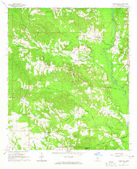
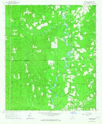
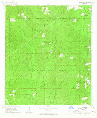
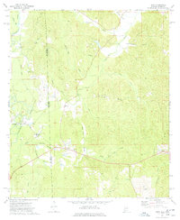
 1964 Denham1965 Print · USGSWayne County's rural character is preserved in this mid-1960s survey, capturing the area as the local economy revolved around the river and rail. Genealogists can trace family roots through numerous landmarks like Denham, Holly Bush Ch, and Antioch Ch.2 unique versions available
 - 1964 Map of Eucutta, 1965 Print
 1964 Eucutta1965 Print · USGSWayne and Clarke counties in the 1960s were defined by rural church congregations and the historical Indian Treaty Boundary. Genealogists can trace local family landmarks at Beaverdam Cem, Jeans Name Ch, and Eucutta.2 unique versions available
 - 1964 Map of Rhodes, 1965 Print
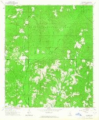
 1964 Rhodes1965 Print · USGSSoutheast Mississippi's piney woods come into focus in the mid-1960s, showing the intersection of three counties and the timber-heavy landscape of the De Soto National Forest. Researchers can locate rural communities like Rhodes and Blodgett or trace family roots at Dykes Chapel and Brown Cem.3 unique versions available
 - 1964 Map of Knobtown, 1965 Print
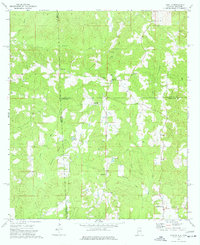
 1964 Knobtown1965 Print · USGSSoutheast Mississippi's river bottomlands and pine forests are captured here in the mid-sixties, split by the winding Chickasawhay River. Researchers can trace rural lineages through numerous community landmarks like Slay Cemetery, Providence Church, and the settlement at Kittrell.3 unique versions available
 - 1964 Map of Myrick, 1965 Print
 1964 Myrick1965 Print · USGSJones County in the mid-sixties reveals a landscape of timber-driven growth and quiet country settlements. Researchers can map out early family landmarks and rural infrastructure, including Dennis Blackledge Cem, the Old Railroad Grade, and Masonite Lake.3 unique versions available
 - 1964 Map of Clara, 1965 Print
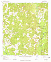
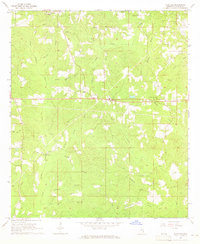
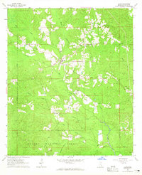 1964 Clara1965 Print · USGSWayne County during the mid-1960s is centered on the rural community of Clara and the deep timberlands of the De Soto National Forest. Researchers can trace local family history through sites like Mills Cemetery and Pittman Cemetery or locate the Big Creek Church and Clara Church.2 unique versions available
 - 1964 Map of Strengthford, 1965 Print
 1964 Strengthford1965 Print · USGSStrengthford and the borderlands of Jones and Wayne Counties are captured here in the mid-sixties within the protected bounds of the De Soto National Forest. Researchers can locate rural landmarks such as Tiger Creek Ch, the Wausau Lookout Tower, and the local Cemetery.2 unique versions available
 - 1964 Map of Mulberry, 1965 Print
 1964 Mulberry1965 Print · USGSSoutheast Mississippi's pine forests and county corners are captured in detail here during the mid-1960s. Genealogists and local historians can locate rural landmarks like Mulberry, Union Grove Ch, and the Hickory Grove Cem tucked within the De Soto National Forest.3 unique versions available
 - 1964 Map of Waynesboro, 1965 Print
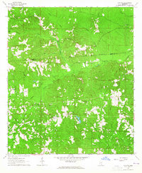
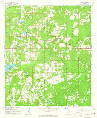
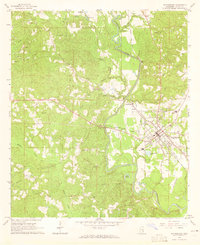 1964 Waynesboro1965 Print · USGSWaynesboro and the Chickasawhay River valley are captured here in the mid-1960s as the local oil and rail industries shaped the county seat. Genealogists can locate family landmarks like Mozingo Cem, Lee Chapel, and the settlement of West King.2 unique versions available
 - 1964 Map of Whistler, 1965 Print
 1964 Whistler1965 Print · USGSIn the mid-1960s, this Wayne County landscape near the Whistler settlement was defined by its timbered ridges and rural crossroads. Researchers can trace family history through sites like Arrington Cem and the old railroad grade.2 unique versions available
 - 1964 Map of Shubuta, 1965 Print
 1964 Shubuta1965 Print · USGSClarke and Wayne Counties at the height of the mid-century oil boom show a landscape defined by the Chickasawhay River and the Gulf Mobile and Ohio rail line. Researchers can trace family roots through sites like Atkinson Cem, New Pilgrim Ch, and the Shubuta Sch.2 unique versions available
 - 1964 Map of Buckatunna, 1965 Print
 1964 Buckatunna1965 Print · USGSWayne County in the mid-sixties centered on the busy rail-and-river corridor of the Chickasawhay River. Genealogists and local historians can trace family-named sites like Powe Cem and Mills Cem or locate the old Buckatunna Sch and Chicora settlement.3 unique versions available
 - 1964 Map of Matherville, 1965 Print
 1964 Matherville1965 Print · USGSWayne and Clarke Counties in the early sixties reveal a landscape shaped by historical land divisions and rural community life. Researchers can trace the Shiloh Treaty Boundary, locate family names at the Gandy Cem, and find old country congregations like St Paul Ch.2 unique versions available
 - 1964 Map of Piave, 1965 Print
 1964 Piave1965 Print · USGSMississippi's piney woods come into focus during the mid-sixties, capturing the rural landscape of the Wayne and Greene county border. Researchers can locate the community of Piave, find Henderson Cem, and trace the paths of Hell Hole Creek and Turkey Fork.4 unique versions available
 - 1974 Map of State Line, 1977 Print
 1974 State Line1977 Print · USGSThe Mississippi-Alabama borderlands come into focus in the mid-1970s, showing the vital rail and timber corridor near State Line. Genealogists and local historians can locate rural landmarks like Yellow Pine, the Gilley Cem, and the Milstead Lookout Tower.2 unique versions available
 - 1974 Map of Melvin, 1977 Print
 1974 Melvin1977 Print · USGSThe Alabama and Mississippi borderlands come to life in the mid-1970s, showing a landscape defined by old treaty lines and early oil exploration. Genealogists can trace family names at Zion Chapel Cem, Stroud Cem, and rural settlements like Melvin and Eiler.
 - 1974 Map of Copeland, 1977 Print
 1974 Copeland1977 Print · USGSStraddling the border in the 1970s, this area shows a landscape defined by traditional rural life and historical lines. You can trace the Old Indian Treaty Boundary and locate community anchors like Lewis Chapel and the Zion Rest Cem.3 unique versions available
 - 1974 Map of Isney, 1977 Print
 1974 Isney1977 Print · USGSThe Alabama and Mississippi borderlands come to life in the mid-1970s, showing a landscape defined by timber, small farms, and winding waterways. Researchers can trace family sites at Cem Coyt Ch, follow the Old Railroad Grade, or locate the crossroads at Isney.
 - 1974 Map of Aquilla, 1977 Print
 1974 Aquilla1977 Print · USGSThe Alabama-Mississippi borderlands come into focus in the 1970s, revealing a landscape of rural communities and winding creek bottoms. Researchers can trace family history through sites like Old Aquilla Cemetery, Kings Chapel, and the settlement at Shady Grove.2 unique versions available
 - 1978 Map of Melvin, 1987 Print
 1978 Melvin1987 Print · USGSThe Alabama-Mississippi borderlands come to life in the 1970s, showcasing a landscape defined by traditional rural settlements and early oil exploration. Genealogists can trace family landmarks like Zion Chapel Cem and Donald Ch near the historic Old Indian Treaty Boundary.
 - 1984 Map of Citronelle
 1984 Citronelle1984 Print · USGSThe Alabama-Mississippi borderlands in the mid-1980s were a hub of timber and rail, spanning from the Leaf River to the Mobile County line. Genealogists can trace family roots through rural communities like Sims Chapel, Leakesville, and Vinegar Bend.2 unique versions available
Showing maps 1-25 of 139
Top cities of Wayne County
Frequently asked questions
- What are the different types of historical maps available for Wayne County?
- What is the oldest map of Wayne County?
- Where can I purchase historical maps of Wayne County for my home or office?
- Where can I download high-res historical maps of Wayne County?
- Are there historical topographic maps available for Wayne County?
- Is there historical aerial imagery available for Wayne County?
- Where are historical maps of Wayne County sourced from?