1940s Maps of Wilkinson County, Mississippi
Explore 5 historic maps of Wilkinson County from the 1940s. These maps offer a rare glimpse into what life looked like during the 1940s — showing old roads, neighborhoods, homes, and landmarks that have changed or disappeared over time.
Whether you're researching your family's past, planning a metal detecting trip, or studying how Wilkinson County's landscape evolved across the 1940s, these high-resolution maps are a powerful tool for exploring the history of this region.
- Focus on a specific era: All maps on this page are from the 1940s, giving you a focused view of this time period.
- See what’s changed: Compare century-old streets, trails, and buildings to today's modern landscape using overlays and satellite layers.
- Research with precision: Use these maps for genealogy, historical research, land use analysis, or educational projects.
- View, download, or print: Maps are fully viewable online in high resolution, and can be downloaded or printed for your own records.
Start exploring Wilkinson County's history through authentic maps from the 1940s. This is your window into the past.
Wilkinson County, MS maps
(5)- 1941 Map of Norwood
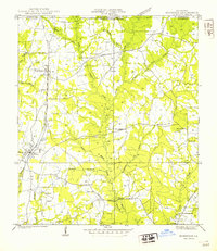 1941 Norwood1941 Print · USGSEast Feliciana Parish near the Mississippi border reveals its 1940s landscape of rural settlements and transport corridors. Genealogists can trace family roots through landmarks like Antioch Ch, Morning Glory Ch, and burial sites such as Beech Grove Cem.
 - 1941 Map of Lost Creek
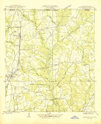
 1941 Lost Creek1941 Print · USGSThe borderlands of East and West Feliciana Parish come alive in this early 1940s survey of rural Louisiana. Genealogists can trace family landmarks like Rogillioville, Hickory Grove Sch, and the Mc Queen Cem alongside the Illinois Central rail line.
 - 1941 Map of Batchelor, 1944 Print
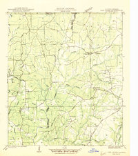
 1941 Batchelor1944 Print · USGSThe Mississippi River's powerful shifts define this corner of Louisiana in the early 1940s, from the oxbows of the Raccourci Old River to the banks of Angola. Local researchers can locate family landmarks such as Mains Plantation, St Stevens Ch, and the Lower Latanache Sch.
 - 1945 Map of Norwood
 1945 Norwood1945 Print · USGSEast Feliciana Parish near the Mississippi border is shown here during the mid-1940s, centered on the Illinois Central rail line. Researchers can trace rural genealogy through landmarks like Pemble Cem, Morning Glory Ch, and the Industrial Training Sch.
 - 1945 Map of Lost Creek
 1945 Lost Creek1945 Print · USGSThe rural border of East and West Feliciana Parishes comes into focus in the mid-1940s, revealing a dense network of country schools and family cemeteries. Genealogists can trace the exact locations of Rogillio-ville, the Mc Queen Cem, and Hickory Grove Sch.
End of results
Showing maps 1-5 of 5
Top cities of Wilkinson County
Frequently asked questions
- What are the different types of historical maps available for Wilkinson County?
- What is the oldest map of Wilkinson County?
- Where can I purchase historical maps of Wilkinson County for my home or office?
- Where can I download high-res historical maps of Wilkinson County?
- Are there historical topographic maps available for Wilkinson County?
- Is there historical aerial imagery available for Wilkinson County?
- Where are historical maps of Wilkinson County sourced from?