1980s Maps of Noxapater, Mississippi
Explore 3 historic maps of Noxapater from the 1980s. These maps offer a rare glimpse into what life looked like during the 1980s — showing old roads, neighborhoods, homes, and landmarks that have changed or disappeared over time.
Whether you're researching your family's past, planning a metal detecting trip, or studying how Noxapater's landscape evolved across the 1980s, these high-resolution maps are a powerful tool for exploring the history of this region.
- Focus on a specific era: All maps on this page are from the 1980s, giving you a focused view of this time period.
- See what’s changed: Compare century-old streets, trails, and buildings to today's modern landscape using overlays and satellite layers.
- Research with precision: Use these maps for genealogy, historical research, land use analysis, or educational projects.
- View, download, or print: Maps are fully viewable online in high resolution, and can be downloaded or printed for your own records.
Start exploring Noxapater's history through authentic maps from the 1980s. This is your window into the past.
Noxapater, MS maps
(3)- 1984 Map of Carthage
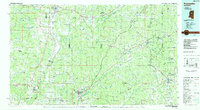
 1984 Carthage1984 Print · USGSLeake and Neshoba counties in the mid-1980s showcase a transition from the Government Hills to the dense Bienville National Forest. Genealogists and researchers can trace the historic Natchez Trace Parkway and local settlements like Plattsburg and Williamsville.
 - 1984 Map of Kosciusko
 1984 Kosciusko1984 Print · USGSCentral Mississippi in the mid-eighties shows a landscape of timberlands and rural crossroads anchored by Kosciusko. Genealogists can trace family roots through numerous country parishes like Bethany Ch and Zion Ch or the path of the Illinois Central Gulf railroad.3 unique versions available
 - 1984 Map of West Point
 1984 West Point1984 Print · USGSNorth-Central Mississippi in the mid-eighties shows a landscape defined by massive water management projects and dense timberlands. Researchers can trace the legacy of rural settlements like Geeslin Corner or the rail corridors of the Illinois Central Gulf RR near Grenada Lake.3 unique versions available
End of results
Showing maps 1-3 of 3
Top cities near Noxapater
- Nanih Waiya historical maps
- Philadelphia historical maps
- Louisville historical maps
- Pearl River historical maps
Frequently asked questions
- What are the different types of historical maps available for Noxapater?
- What is the oldest map of Noxapater?
- Where can I purchase historical maps of Noxapater for my home or office?
- Where can I download high-res historical maps of Noxapater?
- Are there historical topographic maps available for Noxapater?
- Is there historical aerial imagery available for Noxapater?
- Where are historical maps of Noxapater sourced from?