1960s Maps of Barton County, Missouri
Explore 16 historic maps of Barton County from the 1960s. These maps offer a rare glimpse into what life looked like during the 1960s — showing old roads, neighborhoods, homes, and landmarks that have changed or disappeared over time.
Whether you're researching your family's past, planning a metal detecting trip, or studying how Barton County's landscape evolved across the 1960s, these high-resolution maps are a powerful tool for exploring the history of this region.
- Focus on a specific era: All maps on this page are from the 1960s, giving you a focused view of this time period.
- See what’s changed: Compare century-old streets, trails, and buildings to today's modern landscape using overlays and satellite layers.
- Research with precision: Use these maps for genealogy, historical research, land use analysis, or educational projects.
- View, download, or print: Maps are fully viewable online in high resolution, and can be downloaded or printed for your own records.
Start exploring Barton County's history through authentic maps from the 1960s. This is your window into the past.
Barton County, MO maps
(16)- 1962 Map of Jerico Springs, 1963 Print
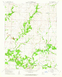
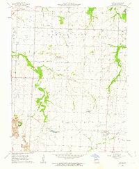
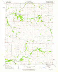
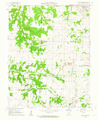 1962 Jerico Springs1963 Print · USGSThe rural borderlands of Cedar, Barton, and Dade Counties are captured here in the early sixties. Genealogists and local historians can locate family landmarks such as Round Prairie Sch, Greenfield Cem, and the church at Stony Point Ch.2 unique versions available
 - 1962 Map of Kenoma, 1963 Print
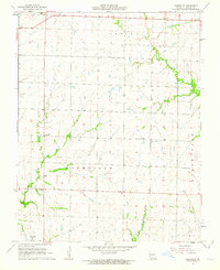
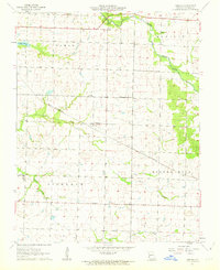 1962 Kenoma1963 Print · USGSBarton County farming life is captured here in the early sixties, showing a landscape defined by traditional township boundaries and the ST Louis - San Francisco railroad. Genealogists can locate family landmarks like Mt Carmel Ch, Fair View Cem, and numerous rural schoolhouses including Glendale Sch.2 unique versions available
 - 1962 Map of Milford, 1963 Print
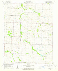
 1962 Milford1963 Print · USGSBarton County life in the early sixties is preserved here through its dense network of rural schools and small creek-side settlements. Genealogists can trace family landmarks like Doylesport Cem, the Bethany Ch church, and schools such as Prairie Rose Sch.
 - 1962 Map of Jasper, 1963 Print
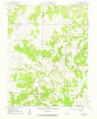
 1962 Jasper1963 Print · USGSJasper and its surrounding townships are shown in the early 1960s as the rail-and-road network supported a thriving rural community. Genealogists can trace family roots through numerous local landmarks, including Stafford Cem, Salem Ch, and the settlement of Carytown.2 unique versions available
 - 1962 Map of Neck City, 1963 Print
 1962 Neck City1963 Print · USGSThe mining landscapes of Jasper County are clearly visible in the early sixties, centered around the industrial activity of Neck City. Researchers can trace the remnants of the Old Railroad Grade and locate family history at Gresham Cem and Preston.2 unique versions available
 - 1962 Map of Sheldon, 1963 Print
 1962 Sheldon1963 Print · USGSThe Missouri prairie around Sheldon is captured here in the early sixties, a landscape defined by the Missouri Pacific rail line and family farming. Genealogists can locate several rural landmarks including Birkett Cem, Shanghi Ch, and Prairie View Sch.2 unique versions available
 - 1962 Map of Lamar North, 1963 Print
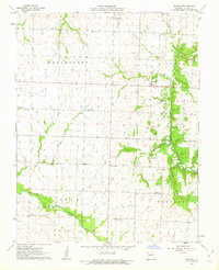
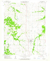
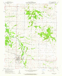
 1962 Lamar North1963 Print · USGSBarton County is shown here in the early 1960s, a landscape shaped by the intersection of the Missouri Pacific and St Louis San Francisco railroads. Researchers can locate rural landmarks like Central Chapel, Bakers Grove Cem, and several country schools.
 - 1962 Map of Bellamy, 1963 Print
 1962 Bellamy1963 Print · USGSWestern Missouri farmland at the Vernon and Barton county line comes into focus in the early sixties. Genealogists can locate family names at the Tolson Cemetery and Warwick Cemetery, or trace the rural routes connecting Bellamy and Rousertown.2 unique versions available
 - 1962 Map of Iantha, 1963 Print
 1962 Iantha1963 Print · USGSBarton County is shown here in the early 1960s, a landscape defined by industrial coal extraction and small-town rail hubs. Researchers can trace the path of the St Louis - San Francisco railroad and locate sites like Verdella Ch, Logue Lake, and the Iantha Cem.
 - 1962 Map of Nashville, 1963 Print
 1962 Nashville1963 Print · USGSBarton County is captured here in the early sixties as a settled landscape of rural schoolhouses and family cemeteries. Genealogists and historians can locate specific sites like Apostolic Christian Ch, Duval Sch, and Pierce Cem near Nashville.
 - 1962 Map of Dudenville, 1963 Print
 1962 Dudenville1963 Print · USGSSouthwest Missouri farmland and rural townships are captured here in the early 1960s at the junction of four counties. Genealogists and local historians can trace the foundations of Dudenville, the location of Unity Sch, and the grounds of Kistler Cem.2 unique versions available
 - 1962 Map of Montevallo, 1963 Print
 1962 Montevallo1963 Print · USGSThe tri-county borderlands of southwest Missouri come into focus in the early sixties, showing the rural landscapes of Montevallo and Olympia. Genealogists can trace family footprints at Walnut Grove Cem and Glade Springs Ch along the winding Horse Creek.2 unique versions available
 - 1962 Map of Maple Grove, 1964 Print
 1962 Maple Grove1964 Print · USGSJasper County during the early 1960s was a patchwork of family farms and rural townships spanning the Barton County line. Genealogists and historians can locate legacy landmarks like Maple Grove, the Spring Hill Sch, and Mitchell Cem.
 - 1962 Map of Bronaugh, 1964 Print
 1962 Bronaugh1964 Print · USGSVernon and Barton Counties appear here in the early sixties, centered on the railroad town of Bronaugh. Researchers can trace the Missouri Pacific line to old sites like Hannon, rural churches like Fairview Ch, and local Strip Mines.2 unique versions available
 - 1962 Map of Golden City, 1964 Print
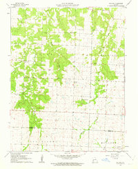
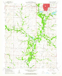
 1962 Golden City1964 Print · USGSBarton and Dade counties come to life in the early sixties, showing a landscape defined by the Frisco railroad and the prairie. Trace family roots at Harlow-Wright Cem or explore the rural layout of Layneville and the industrial Strip Mines.
 - 1962 Map of Lamar South, 1964 Print
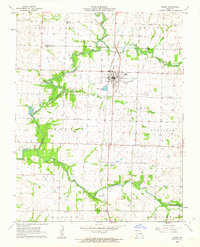
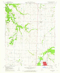
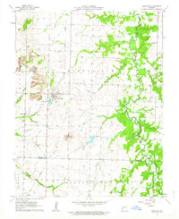
 1962 Lamar South1964 Print · USGSBarton County in the early sixties shows the growth of Lamar City and the rural townships of Richland and North. Genealogists can trace early landmarks like St Marys Cem, Bethel Ch, and forgotten school sites like Ledbetter Sch.
End of results
Showing maps 1-16 of 16
Top cities of Barton County
- Lamar historical maps
- Golden City historical maps
- Liberal historical maps
- Mindenmines historical maps
- Nashville historical maps
- Newport historical maps
See more
Frequently asked questions
- What are the different types of historical maps available for Barton County?
- What is the oldest map of Barton County?
- Where can I purchase historical maps of Barton County for my home or office?
- Where can I download high-res historical maps of Barton County?
- Are there historical topographic maps available for Barton County?
- Is there historical aerial imagery available for Barton County?
- Where are historical maps of Barton County sourced from?