1930s Maps of Bates County, Missouri
Explore 5 historic maps of Bates County from the 1930s. These maps offer a rare glimpse into what life looked like during the 1930s — showing old roads, neighborhoods, homes, and landmarks that have changed or disappeared over time.
Whether you're researching your family's past, planning a metal detecting trip, or studying how Bates County's landscape evolved across the 1930s, these high-resolution maps are a powerful tool for exploring the history of this region.
- Focus on a specific era: All maps on this page are from the 1930s, giving you a focused view of this time period.
- See what’s changed: Compare century-old streets, trails, and buildings to today's modern landscape using overlays and satellite layers.
- Research with precision: Use these maps for genealogy, historical research, land use analysis, or educational projects.
- View, download, or print: Maps are fully viewable online in high resolution, and can be downloaded or printed for your own records.
Start exploring Bates County's history through authentic maps from the 1930s. This is your window into the past.
Bates County, MO maps
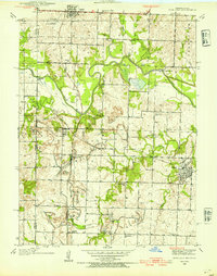
(5)- 1934 Map of Papinsville
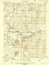 1934 Papinsville1934 Print · USGSBates and Vernon counties are captured here in the mid-1930s, revealing a landscape defined by the winding Mariais Des Cygnes and Osage rivers. Genealogists can trace early landmarks like the Old Harmony Mission Site and various family-named features such as Helem Lake and Maus Cem.2 unique versions available
 - 1934 Map of Rockville
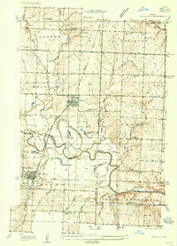 1934 Rockville1934 Print · USGSMid-Missouri river life in the 1930s is centered on the shifting currents of the Osage River and the small-town hubs of the Kansas and Texas railroad. Trace the locations of rural schoolhouses like Mc Davitt Sch or find family roots at Spring Grove Cem.
 - 1936 Map of Rich Hill
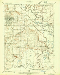 1936 Rich Hill1936 Print · USGSRich Hill and the surrounding river bottoms are captured here in the mid-1930s, during an era of transition for Missouri's coal country. Genealogists and local historians can trace rural school districts like Stone Gate Sch and Panama Sch, or locate family-named sites such as Philbrick Hills and the Jonnum Mines.
 - 1937 Map of New Home, 1939 Print
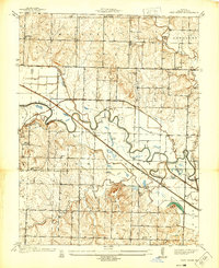 1937 New Home1939 Print · USGSBates County agriculture and industry meet along the Osage River in the late thirties. Genealogists can locate family landmarks like Thomas Cem or Morris Cem, and trace the rural school system from Belmont Sch to Lost Corner Sch.3 unique versions available
 - 1938 Map of Worland, 1954 Print
 1938 Worland1954 Print · USGSBates County sits at a rail-and-river crossroads in the late 1930s, documenting a landscape defined by the Osage River and competing rail lines. Researchers can trace rural genealogy through landmarks like Klondike Sch, Independence Ch, and Salem Cem.3 unique versions available
End of results
Showing maps 1-5 of 5
Top cities of Bates County
- Butler historical maps
- Adrian historical maps
- Rich Hill historical maps
- Hume historical maps
- Spruce historical maps
- Amsterdam historical maps
See more
Frequently asked questions
- What are the different types of historical maps available for Bates County?
- What is the oldest map of Bates County?
- Where can I purchase historical maps of Bates County for my home or office?
- Where can I download high-res historical maps of Bates County?
- Are there historical topographic maps available for Bates County?
- Is there historical aerial imagery available for Bates County?
- Where are historical maps of Bates County sourced from?