1990s Maps of Bates County, Missouri
Explore 8 historic maps of Bates County from the 1990s. These maps offer a rare glimpse into what life looked like during the 1990s — showing old roads, neighborhoods, homes, and landmarks that have changed or disappeared over time.
Whether you're researching your family's past, planning a metal detecting trip, or studying how Bates County's landscape evolved across the 1990s, these high-resolution maps are a powerful tool for exploring the history of this region.
- Focus on a specific era: All maps on this page are from the 1990s, giving you a focused view of this time period.
- See what’s changed: Compare century-old streets, trails, and buildings to today's modern landscape using overlays and satellite layers.
- Research with precision: Use these maps for genealogy, historical research, land use analysis, or educational projects.
- View, download, or print: Maps are fully viewable online in high resolution, and can be downloaded or printed for your own records.
Start exploring Bates County's history through authentic maps from the 1990s. This is your window into the past.
Bates County, MO maps
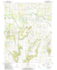
(8)- 1991 Map of New Home
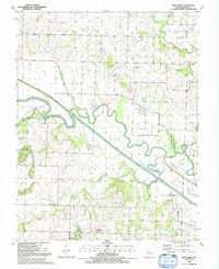 1991 New Home1991 Print · USGSBates County in the early nineties is defined here by the winding MARAIS DES CYGNES RIVER and its complex system of drainage ditches. You can trace family roots at New Home, locate Morris Cem, or follow the path of the OLD RAILROAD GRADE.
 - 1991 Map of Papinville
 1991 Papinville1991 Print · USGSBates and Vernon counties meet at the confluence of the Osage and Marais des Cygnes rivers in the early nineties. Genealogists can locate several remote burial grounds like Flat Rock Cem and Maus Cem or trace the early footprint of Papinville.
 - 1991 Map of Hume
 1991 Hume1991 Print · USGSThe Missouri-Kansas border area near Hume is captured here during the late twentieth century, showing a landscape defined by state-line boundaries and rural heritage. Researchers can locate family sites and landmarks like Lawrence Cem, Amos, and Rocky Mound.
 - 1991 Map of Rich Hill
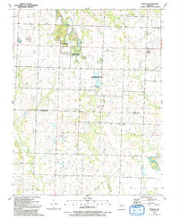
 1991 Rich Hill1991 Print · USGSBates and Vernon Counties were captured in the early nineties as a landscape of river bends and rural crossroads. Local historians can trace the foundations of Rich Hill and its surrounding communities, including Panama, Carbon Center, and the Harmony Sch site.
 - 1991 Map of Worland
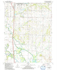
 1991 Worland1991 Print · USGSThe Missouri-Kansas borderlands come into focus in the early nineties, showing a landscape shaped by river engineering and rural industry. Researchers can trace family sites at Salem Cem or locate the defunct Old Railroad Grade near Worland and Tiger.
 - 1991 Map of Butler South
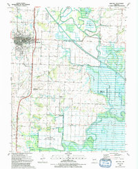
 1991 Butler South1991 Print · USGSBates County south of Butler is captured here in the early 1990s, where the Missouri prairie meets the winding Marais des Cygnes River. Genealogists can locate family landmarks like Fairview Cem, Mt Zion Ch, and the small settlement of Peru.
 - 1991 Map of Rockville
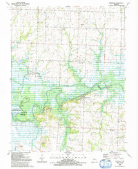
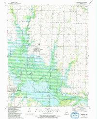 1991 Rockville1991 Print · USGSThe Osage River bottomlands near the Bates and Vernon county line define this late-century landscape. Genealogists and local historians can locate the Rockville Cem, explore the extensive Schell-Osage Wildlife Area, and trace the winding course of Panther Creek.
 - 1991 Map of Sprague
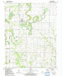
 1991 Sprague1991 Print · USGSBates and Vernon counties in the early 1990s remained a landscape of quiet rural settlements and conservation lands. Genealogists and local historians can trace the positions of Greenlawn Cemetery, Bethel Ch, and the remnant Old RR Grade near Sprague.
End of results
Showing maps 1-8 of 8
Top cities of Bates County
- Butler historical maps
- Adrian historical maps
- Rich Hill historical maps
- Hume historical maps
- Spruce historical maps
- Amsterdam historical maps
See more
Frequently asked questions
- What are the different types of historical maps available for Bates County?
- What is the oldest map of Bates County?
- Where can I purchase historical maps of Bates County for my home or office?
- Where can I download high-res historical maps of Bates County?
- Are there historical topographic maps available for Bates County?
- Is there historical aerial imagery available for Bates County?
- Where are historical maps of Bates County sourced from?