1940s Maps of Bates County, Missouri
Explore 5 historic maps of Bates County from the 1940s. These maps offer a rare glimpse into what life looked like during the 1940s — showing old roads, neighborhoods, homes, and landmarks that have changed or disappeared over time.
Whether you're researching your family's past, planning a metal detecting trip, or studying how Bates County's landscape evolved across the 1940s, these high-resolution maps are a powerful tool for exploring the history of this region.
- Focus on a specific era: All maps on this page are from the 1940s, giving you a focused view of this time period.
- See what’s changed: Compare century-old streets, trails, and buildings to today's modern landscape using overlays and satellite layers.
- Research with precision: Use these maps for genealogy, historical research, land use analysis, or educational projects.
- View, download, or print: Maps are fully viewable online in high resolution, and can be downloaded or printed for your own records.
Start exploring Bates County's history through authentic maps from the 1940s. This is your window into the past.
Bates County, MO maps
(5)- 1940 Map of Worland
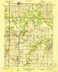 1940 Worland1940 Print · USGSBates County, Missouri, was a landscape of bustling rail towns and schoolhouse districts just before the Second World War. Genealogists can trace family footprints through numerous rural cemeteries like Woodfin Cem and local school sites such as Johnson Sch and Standish Sch.2 unique versions available
 - 1940 Map of Hume, 1954 Print
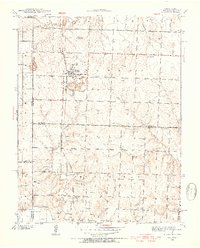 1940 Hume1954 Print · USGSThe Missouri-Kansas borderlands come to life in this late-depression era survey centered on Hume. Genealogists and local historians can trace family roots through numerous rural landmarks like Hume Cem, Union Chapel, and the settlement of Amos.3 unique versions available
 - 1942 Map of Hume
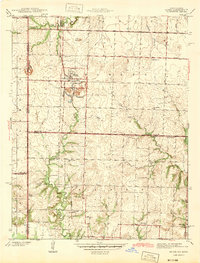 1942 Hume1942 Print · USGSThe Missouri-Kansas border area near Hume is captured here just before the mid-century, showing a landscape tightly woven with railroads and rural school districts. Genealogists can locate family landmarks like Lawrence Cem, Union Chapel, and the now-vanished rail stop at Amos.2 unique versions available
 - 1942 Map of Sprague
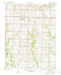 1942 Sprague1942 Print · USGSThe rural borderlands of Bates and Vernon Counties are captured here during the early 1940s, just as the landscape was shifting away from its rail-dependent roots. Researchers can trace the legacy of local education through numerous country schoolhouses like White Rock Sch and Fairview Sch, or locate family sites near Greenlawn Cemetery.3 unique versions available
 - 1947 Map of Lawrence, 1954 Print
 1947 Lawrence1954 Print · USGSEastern Kansas and western Missouri thrive in the late 1940s, showing a landscape defined by major river valleys and a dense railway network. Genealogists can trace family settlements from Lawrence to Greenwood and locate landmarks like Olathe Navy and Lake Lotawana.
End of results
Showing maps 1-5 of 5
Top cities of Bates County
- Butler historical maps
- Adrian historical maps
- Rich Hill historical maps
- Hume historical maps
- Spruce historical maps
- Amsterdam historical maps
See more
Frequently asked questions
- What are the different types of historical maps available for Bates County?
- What is the oldest map of Bates County?
- Where can I purchase historical maps of Bates County for my home or office?
- Where can I download high-res historical maps of Bates County?
- Are there historical topographic maps available for Bates County?
- Is there historical aerial imagery available for Bates County?
- Where are historical maps of Bates County sourced from?