1980s Maps of Marble Hill, Missouri
Explore 7 historic maps of Marble Hill from the 1980s. These maps offer a rare glimpse into what life looked like during the 1980s — showing old roads, neighborhoods, homes, and landmarks that have changed or disappeared over time.
Whether you're researching your family's past, planning a metal detecting trip, or studying how Marble Hill's landscape evolved across the 1980s, these high-resolution maps are a powerful tool for exploring the history of this region.
- Focus on a specific era: All maps on this page are from the 1980s, giving you a focused view of this time period.
- See what’s changed: Compare century-old streets, trails, and buildings to today's modern landscape using overlays and satellite layers.
- Research with precision: Use these maps for genealogy, historical research, land use analysis, or educational projects.
- View, download, or print: Maps are fully viewable online in high resolution, and can be downloaded or printed for your own records.
Start exploring Marble Hill's history through authentic maps from the 1980s. This is your window into the past.
Marble Hill, MO maps
(7)- 1980 Map of Marble Hill
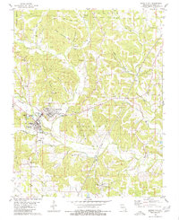 1980 Marble Hill1980 Print · USGSBollinger County in the late twentieth century reveals a transition from traditional rail-reliant settlements to modern utility and transport. Genealogists can trace family lines at St Johns Cem or Crossroads Cem, while following the Old Railroad Grade near Laflin.2 unique versions available
 - 1980 Map of Glenallen
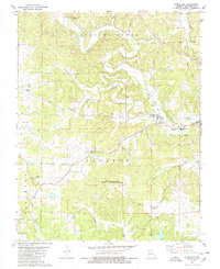 1980 Glenallen1980 Print · USGSBollinger County in the 1970s reveals a landscape of deep hollows and creek-side settlements connected by an evolving road network and an Old Railroad Grade. Researchers can pinpoint family burial sites like Mouser Cem and Dry Creek Cem, or locate the Woodland Sch and New Salem Ch.2 unique versions available
 - 1984 Map of Cape Girardeau, 1985 Print
 1984 Cape Girardeau1985 Print · USGSThe tri-state junction of Missouri, Illinois, and Kentucky in the mid-1980s was a bustling corridor defined by its massive river systems and complex rail lines. Researchers can trace the paths of the Missouri Pacific RR, explore the Shawnee National Forest, or locate small settlements like Marble Hill and Advance.
 - 1986 Map of Cape Girardeau
 1986 Cape Girardeau1986 Print · USGSThe Missouri-Illinois-Kentucky borderlands come into focus in the mid-1980s as the river-and-rail economy shapes the landscape near the Great Rivers confluence. Researchers can trace historic rail lines and old settlements like Gordonville, New Hamburg, and the Trail of Tears State Park.
 - 1986 Map of Piedmont
 1986 Piedmont1986 Print · USGSThe Missouri Ozarks are captured here in the mid-eighties as a region of dense state forests and critical river management. Genealogists and historians can trace family-named features and rural settlements like Piedmont, Lesterville, and the Yokum School.2 unique versions available
 - 1987 Map of Paducah, 1988 Print
 1987 Paducah1988 Print · USGSThe Lower Ohio Valley and the Illinois Ozarks come alive in this late twentieth-century regional survey. Genealogists and local historians can trace river-town roots and state park landmarks from Metropolis to Cape Girardeau and Trail of Tears State Park.
 - 1989 Map of Rolla
 1989 Rolla1989 Print · USGSThe Missouri Ozarks are captured in the late eighties as a landscape of national forests and historic mining towns. Researchers can trace the rail lines of the Missouri Pacific RR or locate landmarks like Taum Sauk Mtn and Elephant Rocks State Park.
End of results
Showing maps 1-7 of 7
Top cities near Marble Hill
- Advance historical maps
- Marquand historical maps
- Sedgewickville historical maps
- Whitewater historical maps
- Allenville historical maps
- Zalma historical maps
Top neighborhoods of Marble Hill
Frequently asked questions
- What are the different types of historical maps available for Marble Hill?
- What is the oldest map of Marble Hill?
- Where can I purchase historical maps of Marble Hill for my home or office?
- Where can I download high-res historical maps of Marble Hill?
- Are there historical topographic maps available for Marble Hill?
- Is there historical aerial imagery available for Marble Hill?
- Where are historical maps of Marble Hill sourced from?