1930s Maps of Marble Hill, Missouri
Explore 4 historic maps of Marble Hill from the 1930s. These maps offer a rare glimpse into what life looked like during the 1930s — showing old roads, neighborhoods, homes, and landmarks that have changed or disappeared over time.
Whether you're researching your family's past, planning a metal detecting trip, or studying how Marble Hill's landscape evolved across the 1930s, these high-resolution maps are a powerful tool for exploring the history of this region.
- Focus on a specific era: All maps on this page are from the 1930s, giving you a focused view of this time period.
- See what’s changed: Compare century-old streets, trails, and buildings to today's modern landscape using overlays and satellite layers.
- Research with precision: Use these maps for genealogy, historical research, land use analysis, or educational projects.
- View, download, or print: Maps are fully viewable online in high resolution, and can be downloaded or printed for your own records.
Start exploring Marble Hill's history through authentic maps from the 1930s. This is your window into the past.
Marble Hill, MO maps
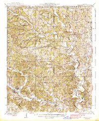
(4)- 1933 Map of Marble Hill, 1964 Print
 1933 Marble Hill1964 Print · USGSBollinger and Cape Girardeau counties in the early 1930s reveal a landscape of rural schoolhouses and family-named landmarks. Trace the Missouri Pacific rail line through Lutesville or find local community sites like Whiskey Sch and Gravel Hill Ch.3 unique versions available
 - 1933 Map of Marquand, 1966 Print
 1933 Marquand1966 Print · USGSMadison and Bollinger counties are shown in the early 1930s, documenting a landscape defined by the Missouri Pacific rail corridor and the Castor River. Genealogists can trace family landmarks like Younts Store, the Starkey Mine, and numerous remote burial grounds including the Whitener Cem.2 unique versions available
 - 1937 Map of Marble Hill
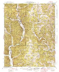
 1937 Marble Hill1937 Print · USGSSoutheast Missouri in the mid-thirties remains a landscape of small crossroads and one-room schools like Hamestring Sch. You can trace the Missouri Pacific rail line through Lutesville or locate family sites at Pulliam Cem and Barks Chapel.2 unique versions available
 - 1938 Map of Marquand
 1938 Marquand1938 Print · USGSThe Missouri Ozarks borderlands appear here in the late 1930s, showing a landscape of river-valley towns and hilltop mines. Researchers can trace ancestral locations through dozens of rural sites, including Rhodes Chapel, Starke Mine, and the Marquand rail depot.2 unique versions available
End of results
Showing maps 1-4 of 4
Top cities near Marble Hill
- Advance historical maps
- Marquand historical maps
- Sedgewickville historical maps
- Whitewater historical maps
- Allenville historical maps
- Zalma historical maps
Top neighborhoods of Marble Hill
Frequently asked questions
- What are the different types of historical maps available for Marble Hill?
- What is the oldest map of Marble Hill?
- Where can I purchase historical maps of Marble Hill for my home or office?
- Where can I download high-res historical maps of Marble Hill?
- Are there historical topographic maps available for Marble Hill?
- Is there historical aerial imagery available for Marble Hill?
- Where are historical maps of Marble Hill sourced from?