1920s Maps of Agency, Missouri
Explore 2 historic maps of Agency from the 1920s. These maps offer a rare glimpse into what life looked like during the 1920s — showing old roads, neighborhoods, homes, and landmarks that have changed or disappeared over time.
Whether you're researching your family's past, planning a metal detecting trip, or studying how Agency's landscape evolved across the 1920s, these high-resolution maps are a powerful tool for exploring the history of this region.
- Focus on a specific era: All maps on this page are from the 1920s, giving you a focused view of this time period.
- See what’s changed: Compare century-old streets, trails, and buildings to today's modern landscape using overlays and satellite layers.
- Research with precision: Use these maps for genealogy, historical research, land use analysis, or educational projects.
- View, download, or print: Maps are fully viewable online in high resolution, and can be downloaded or printed for your own records.
Start exploring Agency's history through authentic maps from the 1920s. This is your window into the past.
Agency, MO maps
(2)- 1925 Map of Gower
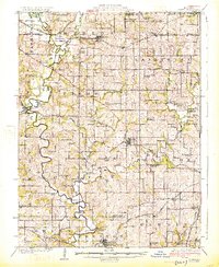 1925 Gower1925 Print · USGSClinton and Buchanan Counties at the mid-twenties are mapped here as a network of rail-side towns and small farm districts. Genealogists can locate dozens of rural landmarks like Matheys Mill, Blinkley Cem, and the many namesake schoolhouses such as Mc Gruhey School.3 unique versions available
 - 1927 Map of Dearborn
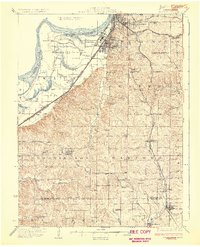 1927 Dearborn1927 Print · USGSNorthwest Missouri thrived as a rail and river hub during the mid-twenties, where the industrial Stockyards of Saint Joseph gave way to a landscape of oxbow lakes. Genealogists can trace family roots through a dense network of rural landmarks, including New Market, De Kalb, and nearly two dozen local schools like Sleepy Hollow School.3 unique versions available
End of results
Showing maps 1-2 of 2
Top cities near Agency
- Saint Joseph historical maps
- Smithville historical maps
- Gower historical maps
- Wathena historical maps
- Elwood historical maps
- Edgerton historical maps
See more
Frequently asked questions
- What are the different types of historical maps available for Agency?
- What is the oldest map of Agency?
- Where can I purchase historical maps of Agency for my home or office?
- Where can I download high-res historical maps of Agency?
- Are there historical topographic maps available for Agency?
- Is there historical aerial imagery available for Agency?
- Where are historical maps of Agency sourced from?