1980s Maps of Mock Corner, Missouri
Explore 2 historic maps of Mock Corner from the 1980s. These maps offer a rare glimpse into what life looked like during the 1980s — showing old roads, neighborhoods, homes, and landmarks that have changed or disappeared over time.
Whether you're researching your family's past, planning a metal detecting trip, or studying how Mock Corner's landscape evolved across the 1980s, these high-resolution maps are a powerful tool for exploring the history of this region.
- Focus on a specific era: All maps on this page are from the 1980s, giving you a focused view of this time period.
- See what’s changed: Compare century-old streets, trails, and buildings to today's modern landscape using overlays and satellite layers.
- Research with precision: Use these maps for genealogy, historical research, land use analysis, or educational projects.
- View, download, or print: Maps are fully viewable online in high resolution, and can be downloaded or printed for your own records.
Start exploring Mock Corner's history through authentic maps from the 1980s. This is your window into the past.
Mock Corner, MO maps
(2)- 1984 Map of De Kalb
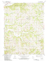 1984 De Kalb1984 Print · USGSDe Kalb and the surrounding Missouri townships of Bloomington and Rush appear here in the mid-1980s, revealing a landscape of winding creeks and family history. Researchers can trace ancestral sites like Jones Cem, Bells Cem, and the hamlet of Mock Corner.
 - 1986 Map of Saint Joseph
 1986 Saint Joseph1986 Print · USGSNorthwest Missouri thrived as a regional transportation and educational hub during the mid-eighties, centered on the historic river city of Saint Joseph. Researchers can locate specific local landmarks like Burlington Cemetery, Pigeon Hill Church, and the winding Pony Express Trail.2 unique versions available
End of results
Showing maps 1-2 of 2
Top cities near Mock Corner
- Kansas City historical maps
- Saint Joseph historical maps
- Leavenworth historical maps
- Atchison historical maps
- Platte City historical maps
- Kickapoo historical maps
See more
Frequently asked questions
- What are the different types of historical maps available for Mock Corner?
- What is the oldest map of Mock Corner?
- Where can I purchase historical maps of Mock Corner for my home or office?
- Where can I download high-res historical maps of Mock Corner?
- Are there historical topographic maps available for Mock Corner?
- Is there historical aerial imagery available for Mock Corner?
- Where are historical maps of Mock Corner sourced from?