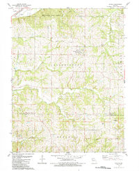
1984 Map of De Kalb
USGS Topo · Published 1984About this map
De Kalb serves as the central hub of this Missouri landscape, situated within a complex network of drainages including Lost Creek, Sugar Creek, and Contrary Creek. The topography is defined by the townships of Wayne, Bloomington, Rush, and Crawford, showing a rural landscape in the mid-1980s where agriculture and conservation meet. The northern edge is anchored by Bluewoods State Forest, while the presence of an Old Railroad Grade and a Landing Strip point to the evolution of local transportation.
Find a feature on this map
32 named features on this map. Tap any name to fly to it.
Don’t see what you’re looking for? This feature index may not catch every label — zoom into the map to look around manually.
Map Details
Editions of this 1984 De Kalb Map
This is the sole edition of this map. No revisions or reprints were ever made.
Other maps of this area

1885 · Atchison
USGS Topo · 1:125,000

1886 · Oskaloosa
USGS Topo · 1:125,000

1888 · Oskaloosa
USGS Topo · 1:125,000

1888 · Atchison
USGS Topo · 1:125,000

1890 · Kansas City
USGS Topo · 1:125,000

1893 · Atchison
USGS Topo · 1:125,000

1894 · Kansas City
USGS Topo · 1:125,000

1894 · Oskaloosa
USGS Topo · 1:125,000

1910 · Leavenworth
USGS Topo · 1:62,500

1926 · Atchison
USGS Topo · 1:62,500