1980s Maps of Dodds, Missouri
Explore 2 historic maps of Dodds from the 1980s. These maps offer a rare glimpse into what life looked like during the 1980s — showing old roads, neighborhoods, homes, and landmarks that have changed or disappeared over time.
Whether you're researching your family's past, planning a metal detecting trip, or studying how Dodds's landscape evolved across the 1980s, these high-resolution maps are a powerful tool for exploring the history of this region.
- Focus on a specific era: All maps on this page are from the 1980s, giving you a focused view of this time period.
- See what’s changed: Compare century-old streets, trails, and buildings to today's modern landscape using overlays and satellite layers.
- Research with precision: Use these maps for genealogy, historical research, land use analysis, or educational projects.
- View, download, or print: Maps are fully viewable online in high resolution, and can be downloaded or printed for your own records.
Start exploring Dodds's history through authentic maps from the 1980s. This is your window into the past.
Dodds, MO maps
(2)- 1983 Map of Bollinger Creek
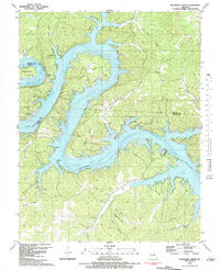 1983 Bollinger Creek1983 Print · USGSThe Lake of the Ozarks shoreline and the Osage River valley are shown here in the early eighties as the area developed into a recreational hub. Researchers can locate family burial grounds like Parish Cem and Woolery Cem or the remote Ivy Bend Landing Strip.
 - 1983 Map of Lake Of The Ozarks, 1984 Print
 1983 Lake Of The Ozarks1984 Print · USGSThe Lake of the Ozarks region in the early eighties shows a landscape of deep river bends and growing recreation. Genealogists can trace family names and small settlements from Versailles to Meta and locate old mining sites like Tiff Mine.
End of results
Showing maps 1-2 of 2
Top cities near Dodds
- Camdenton historical maps
- Laurie historical maps
- Sunrise Beach historical maps
- Macks Creek historical maps
- Gravois Mills historical maps
- Preston historical maps
See more
Frequently asked questions
- What are the different types of historical maps available for Dodds?
- What is the oldest map of Dodds?
- Where can I purchase historical maps of Dodds for my home or office?
- Where can I download high-res historical maps of Dodds?
- Are there historical topographic maps available for Dodds?
- Is there historical aerial imagery available for Dodds?
- Where are historical maps of Dodds sourced from?