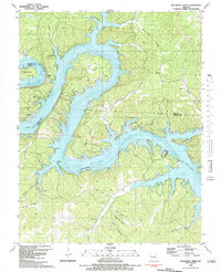
1983 Map of Bollinger Creek
USGS Topo · Published 1983About this map
Lake of the Ozarks dominates the landscape of this 1983 survey, where the winding Osage River channel creates a complex network of peninsulas and deep hollows. The map illustrates the transition of the region into a recreational and residential area during the early 1980s, evidenced by the development of Brown Bend, Ivy Bend, and the Ivy Bend Landing Strip. Amidst the modern growth, several family landmarks and community sites remain, including the Christian Ch of the Ozarks, Ivy Bend Mission, and the remote Camp Horn. Genealogists and local historians can trace legacy burial sites throughout the rugged terrain, such as Parish Cem near the Morgan and Camden county line, and Woolery Cem situated along Bollinger Creek. The map provides a detailed view of the many named drainages like Wildcat Hollow and Pearson Hollow that feed into the reservoir.
Find a feature on this map
43 named features on this map. Tap any name to fly to it.
Don’t see what you’re looking for? This feature index may not catch every label — zoom into the map to look around manually.
Map Details
Editions of this 1983 Bollinger Creek Map
This is the sole edition of this map. No revisions or reprints were ever made.
Other maps of this area

1887 · Warsaw
USGS Topo · 1:125,000

1888 · Versailles
USGS Topo · 1:125,000

1893 · Versailles
USGS Topo · 1:125,000

1894 · Warsaw
USGS Topo · 1:125,000

1904 · Gravois Mills
USGS Topo · 1:62,500

1934 · Purvis
USGS Topo · 1:24,000

1934 · Irontown Ferry
USGS Topo · 1:24,000

1934 · Green Bay Terrace
USGS Topo · 1:24,000

1935 · Gravois Mills
USGS Topo · 1:24,000

1935 · Barnumton
USGS Topo · 1:24,000