1960s Maps of Cape Girardeau County, Missouri
Explore 11 historic maps of Cape Girardeau County from the 1960s. These maps offer a rare glimpse into what life looked like during the 1960s — showing old roads, neighborhoods, homes, and landmarks that have changed or disappeared over time.
Whether you're researching your family's past, planning a metal detecting trip, or studying how Cape Girardeau County's landscape evolved across the 1960s, these high-resolution maps are a powerful tool for exploring the history of this region.
- Focus on a specific era: All maps on this page are from the 1960s, giving you a focused view of this time period.
- See what’s changed: Compare century-old streets, trails, and buildings to today's modern landscape using overlays and satellite layers.
- Research with precision: Use these maps for genealogy, historical research, land use analysis, or educational projects.
- View, download, or print: Maps are fully viewable online in high resolution, and can be downloaded or printed for your own records.
Start exploring Cape Girardeau County's history through authentic maps from the 1960s. This is your window into the past.
Cape Girardeau County, MO maps
(11)- 1961 Map of Paducah
 1961 Paducah1961 Print · USGSThe Lower Ohio Valley at mid-century is a landscape defined by its great rivers and newly formed reservoirs. Researchers can trace the riverfronts of Paducah and Metropolis, or locate smaller settlements like Old Shawneetown and Cave in Rock along the banks.2 unique versions available
 - 1963 Map of Scott City, 1964 Print
 1963 Scott City1964 Print · USGSSoutheastern Missouri at the start of the 1960s shows a landscape of engineered drainage and rail-side growth. Trace local history through the streets of Scott City and Ilmo, or find family roots at Ancell Cem and Spradlin Cem.2 unique versions available
 - 1963 Map of Whitewater, 1964 Print
 1963 Whitewater1964 Print · USGSWhitewater and the surrounding river bottoms are captured here in the early sixties as massive hydrologic projects reshaped the land. Genealogists can trace family roots through locations like Passover Ch, Frazier Cem, and the rural School No R 5.2 unique versions available
 - 1963 Map of Chaffee, 1964 Print
 1963 Chaffee1964 Print · USGSSoutheast Missouri’s rail and river landscape is captured here during the early sixties, showing the complex drainage systems of the Bootheel fringe. Genealogists and rail historians can trace the paths of three major railroads and locate sites like Union Park Cem, Lake Twa-ap-pi-ty, and Hindman.2 unique versions available
 - 1963 Map of Morley, 1968 Print
 1963 Morley1968 Print · USGSScott County in the early 1960s was a landscape defined by industrial rail lines and significant drainage works like the Headwater Diversion Channel. Researchers can trace rural family roots at Guardian Angel Ch or locate mid-century landmarks like the Cape Girardeau Municipal Airport and Marquette Lakes.
 - 1964 Map of Paducah
 1964 Paducah1964 Print · USGSThe river-and-rail corridor of Southern Illinois and Western Kentucky is captured here during the height of the mid-century industrial era. Genealogists and researchers can trace local landmarks across several counties, from the rail yards of Paducah to the waters of Crab Orchard Lake and Kentucky Reservoir.2 unique versions available
 - 1966 Map of Thebes, 1968 Print
 1966 Thebes1968 Print · USGSThe Mississippi River forms a busy industrial and transit corridor between Missouri and Illinois in the late sixties. Genealogists can trace family names at Hobbs Cem and Grays Point Cem while rail fans follow the Missouri Pacific Railroad through Thebes.2 unique versions available
 - 1966 Map of Jackson, 1968 Print
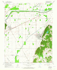
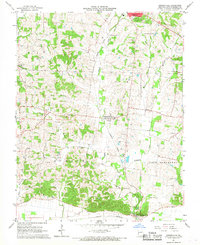
 1966 Jackson1968 Print · USGSJackson and its northern neighbors were transitioning into the interstate era during the mid-sixties, balancing traditional rail-side life with new highway access. Researchers can trace numerous family burial sites like Ramsey Cem and Wheeler Cem, or locate landmarks such as the Drive-in Theater and Pleasant Hill Ch.2 unique versions available
 - 1967 Map of Cape Girardeau NE, 1968 Print
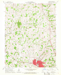
 1967 Cape Girardeau NE1968 Print · USGSCape Girardeau County in the late sixties maintains its rural heritage and historical landmarks before modern expansion. Genealogists and local historians can trace family locations through Old McKendree Chapel and numerous burial grounds like Zierath Cem and Noland Cem.2 unique versions available
 - 1967 Map of Cape Girardeau, 1968 Print
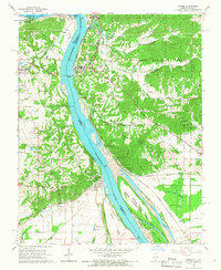
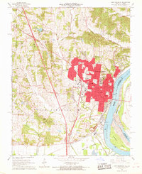 1967 Cape Girardeau1968 Print · USGSCape Girardeau is shown here as a thriving river city and educational hub during the late sixties. Researchers can trace institutional footprints like Southeast Missouri State College or find family history at Old Hanover Cem and St Marys Cem.2 unique versions available
 - 1967 Map of Gordonville, 1968 Print
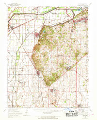
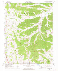
 1967 Gordonville1968 Print · USGSThe rural landscape of Cape Girardeau County in the late sixties shows a transition between traditional farming communities and developing infrastructure. Genealogists and historians can trace family roots through numerous burial sites like Suedekum Cem or visit landmarks like Oak Grove Sch and St James Ch.2 unique versions available
End of results
Showing maps 1-11 of 11
Top cities of Cape Girardeau County
- Cape Girardeau historical maps
- Jackson historical maps
- Delta historical maps
- Gordonville historical maps
- Oak Ridge historical maps
- Pocahontas historical maps
See more
Frequently asked questions
- What are the different types of historical maps available for Cape Girardeau County?
- What is the oldest map of Cape Girardeau County?
- Where can I purchase historical maps of Cape Girardeau County for my home or office?
- Where can I download high-res historical maps of Cape Girardeau County?
- Are there historical topographic maps available for Cape Girardeau County?
- Is there historical aerial imagery available for Cape Girardeau County?
- Where are historical maps of Cape Girardeau County sourced from?