1990s Maps of Leemon, Missouri
Explore 1 historic maps of Leemon from the 1990s. These maps offer a rare glimpse into what life looked like during the 1990s — showing old roads, neighborhoods, homes, and landmarks that have changed or disappeared over time.
Whether you're researching your family's past, planning a metal detecting trip, or studying how Leemon's landscape evolved across the 1990s, these high-resolution maps are a powerful tool for exploring the history of this region.
- Focus on a specific era: All maps on this page are from the 1990s, giving you a focused view of this time period.
- See what’s changed: Compare century-old streets, trails, and buildings to today's modern landscape using overlays and satellite layers.
- Research with precision: Use these maps for genealogy, historical research, land use analysis, or educational projects.
- View, download, or print: Maps are fully viewable online in high resolution, and can be downloaded or printed for your own records.
Start exploring Leemon's history through authentic maps from the 1990s. This is your window into the past.
Leemon, MO maps
(1)- 1993 Map of Cape Girardeau NE, 1996 Print
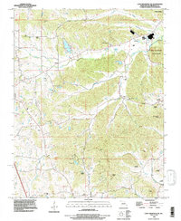 1993 Cape Girardeau NE1996 Print · USGSThe bluffs and creek valleys of Cape Girardeau County are captured here in the early nineties, centered on the riverfront at Neelys Landing. Researchers can trace local lineage through a dozen small burial grounds like Iona Cemetery and Vangilder Cemetery or explore the bounds of Trail of Tears State Park.
End of results
Showing maps 1-1 of 1
Top cities near Leemon
- Cape Girardeau historical maps
- Jackson historical maps
- Scott City historical maps
- Grand Tower historical maps
- Gordonville historical maps
- McClure historical maps
See more
Frequently asked questions
- What are the different types of historical maps available for Leemon?
- What is the oldest map of Leemon?
- Where can I purchase historical maps of Leemon for my home or office?
- Where can I download high-res historical maps of Leemon?
- Are there historical topographic maps available for Leemon?
- Is there historical aerial imagery available for Leemon?
- Where are historical maps of Leemon sourced from?