1960s Maps of Clark County, Missouri
Explore 8 historic maps of Clark County from the 1960s. These maps offer a rare glimpse into what life looked like during the 1960s — showing old roads, neighborhoods, homes, and landmarks that have changed or disappeared over time.
Whether you're researching your family's past, planning a metal detecting trip, or studying how Clark County's landscape evolved across the 1960s, these high-resolution maps are a powerful tool for exploring the history of this region.
- Focus on a specific era: All maps on this page are from the 1960s, giving you a focused view of this time period.
- See what’s changed: Compare century-old streets, trails, and buildings to today's modern landscape using overlays and satellite layers.
- Research with precision: Use these maps for genealogy, historical research, land use analysis, or educational projects.
- View, download, or print: Maps are fully viewable online in high resolution, and can be downloaded or printed for your own records.
Start exploring Clark County's history through authentic maps from the 1960s. This is your window into the past.
Clark County, MO maps
(8)- 1961 Map of Burlington
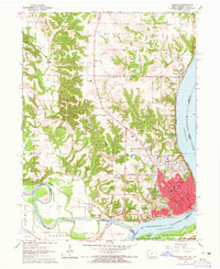
 1961 Burlington1961 Print · USGSThe tri-state borderlands along the Mississippi River are captured here during the late fifties and early sixties, showing the vital river-and-rail economy of Iowa, Illinois, and Missouri. Genealogists and historians can trace the development of major hubs like Galesburg and Macomb alongside landmark sites such as the Iowa Ordnance Plant and the historic river town of Nauvoo.
 - 1963 Map of Burlington
 1963 Burlington1963 Print · USGSThe tri-state river country of the Mississippi and Illinois valleys comes alive in this mid-century survey. Genealogists and historians can trace the industrial and academic growth of the region, from the Iowa Ordnance Plant to campuses like Knox College and Western Illinois University.
 - 1964 Map of Keokuk, 1965 Print
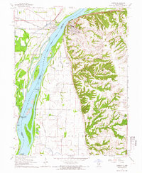
 1964 Keokuk1965 Print · USGSKeokuk and its river-junction landscape are captured in the mid-sixties, showing a city built on rail and water commerce. Genealogists can trace family names through several historic sites, including the National Cemetery, Summitville, and The Yellow Banks Cem.3 unique versions available
 - 1964 Map of Warsaw, 1966 Print
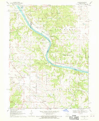
 1964 Warsaw1966 Print · USGSWarsaw and Alexandria occupy opposite sides of the Mississippi River in the mid-sixties, linked by a landscape of shifting sloughs and rail lines. You can trace the path of the Chicago Burlington and Quincy railroad through Gregory Landing or locate the Rockford Sch and Green Plain Cem.3 unique versions available
 - 1968 Map of Anson, 1970 Print
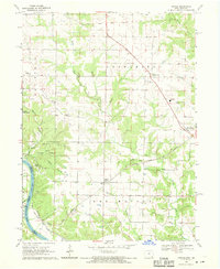
 1968 Anson1970 Print · USGSThe Fox River valley along the Missouri-Iowa border is documented here in the late sixties. Genealogists and local historians can trace family burial sites and rural institutions like St Thomas Cem, Duncan Sch, and the settlement at Chambersburg.2 unique versions available
 - 1968 Map of Argyle, 1970 Print
 1968 Argyle1970 Print · USGSThe Des Moines River valley and its surrounding timberlands are shown here in the late sixties as the railway era persists. Family researchers can locate rural landmarks like St Marys Church, Charleston Cem, and the old New Boston settlement.2 unique versions available
 - 1968 Map of Croton, 1970 Print
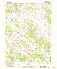
 1968 Croton1970 Print · USGSThe borderlands of Missouri and Iowa are captured here in the late sixties as the Des Moines River winds through timber and farmland. Genealogists and historians can trace the Old Indian Treaty Boundary and locate family burial sites like Shaffer Cem and Walker Cem.2 unique versions available
 - 1968 Map of Mount Sterling, 1970 Print
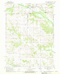 1968 Mount Sterling1970 Print · USGSCrossing the Iowa-Missouri border in the late sixties, this survey captures the rural landscape between Mount Sterling and Prospect Grove. Genealogists can trace family roots at Harness Cem, Blackledge Cem, and Asbury Ch along the Fox River valley.3 unique versions available
End of results
Showing maps 1-8 of 8
Top cities of Clark County
- Kahoka historical maps
- Wayland historical maps
- Wyaconda historical maps
- Alexandria historical maps
- Revere historical maps
- Luray historical maps
Frequently asked questions
- What are the different types of historical maps available for Clark County?
- What is the oldest map of Clark County?
- Where can I purchase historical maps of Clark County for my home or office?
- Where can I download high-res historical maps of Clark County?
- Are there historical topographic maps available for Clark County?
- Is there historical aerial imagery available for Clark County?
- Where are historical maps of Clark County sourced from?