1900s (20th Century) Maps of Cole County, Missouri
Explore 32 historic maps of Cole County from the 1900s (20th Century). These maps offer a rare glimpse into what life looked like during the 1900s — showing old roads, neighborhoods, homes, and landmarks that have changed or disappeared over time.
Whether you're researching your family's past, planning a metal detecting trip, or studying how Cole County's landscape evolved across the 1900s, these high-resolution maps are a powerful tool for exploring the history of this region.
- Focus on a specific era: All maps on this page are from the 1900s, giving you a focused view of this time period.
- See what’s changed: Compare century-old streets, trails, and buildings to today's modern landscape using overlays and satellite layers.
- Research with precision: Use these maps for genealogy, historical research, land use analysis, or educational projects.
- View, download, or print: Maps are fully viewable online in high resolution, and can be downloaded or printed for your own records.
Start exploring Cole County's history through authentic maps from the 1900s. This is your window into the past.
Cole County, MO maps
(32)- 1939 Map of Jefferson City
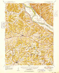
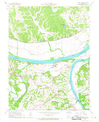
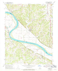
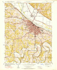 1939 Jefferson City1939 Print · USGSJefferson City and the winding Moreau River are captured here in the late thirties, showing the Missouri state capital as it functioned before mid-century expansion. Genealogists can locate family landmarks like Shumate Chapel Cem, the Lincoln Institute, and rural outposts like Grays.2 unique versions available
 - 1939 Map of Jefferson City, 1954 Print
 1939 Jefferson City1954 Print · USGSMissouri's capital and the surrounding river bluffs are captured here in the late thirties, showing the region's transition between rural farmland and state governance. Researchers can locate family landmarks like Providence Cem, the Algoa Reformatory, and various schools such as Sycamore Sch.2 unique versions available
 - 1942 Map of Jefferson City
 1942 Jefferson City1942 Print · USGSJefferson City and the surrounding river bluffs are captured in the early years of the war, when rail travel and state agriculture dominated the landscape. Genealogists can locate family-named landmarks and rural schools like Hall Sch, Williams Cem, and the small settlement of New Bloomfield.2 unique versions available
 - 1947 Map of Jefferson City, 1949 Print
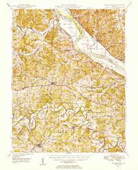
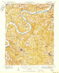
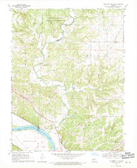
 1947 Jefferson City1949 Print · USGSCentral Missouri and the northern Ozarks come into focus in this late 1940s survey of the river-and-rail landscape. Genealogists and historians can trace the growth of Jefferson City and Sedalia or locate family roots near Bagnell Dam and the Lake of the Ozarks.
 - 1948 Map of Centertown, 1954 Print
 1948 Centertown1954 Print · USGSMid-Missouri farming life in the late forties is captured here, centered on the river bluffs and rail lines between Centertown and Russellville. Researchers can trace rural school districts like Brick School and locate family burial grounds including Enloe Cem and Eberhardt Cem.
 - 1948 Map of Meta, 1963 Print
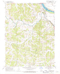
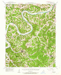 1948 Meta1963 Print · USGSThe Osage River valley in the late 1940s shows a landscape of river ferries and emerging rail hubs. Researchers can trace family sites like St Cecilia Cem & Ch, early river infrastructure at the US Lock & Dam, and rural centers such as Koeltztown.
 - 1948 Map of Eugene, 1966 Print
 1948 Eugene1966 Print · USGSCentral Missouri rural life is captured here in the years following the war, centered on the rail corridor through Eugene. Researchers can trace family sites and community landmarks like Marys Home, Rush Chapel, and the river bluffs along the Osage River.2 unique versions available
 - 1949 Map of Centertown
 1949 Centertown1949 Print · USGSMid-Missouri river life and rural settlement are captured here just after the war, from the Missouri River bottoms to the uplands. Genealogists can trace family roots through numerous sites like Sweetwater Cem, Bonds Chapel, and the National Cem.
 - 1950 Map of Meta
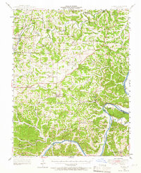
 1950 Meta1950 Print · USGSMid-century life in the Missouri river hills centers on the winding Osage River and the small parish towns of the interior. Genealogists can trace family roots through several rural schools and burial grounds, including St Cecelia Cem and the Bodie Ferry (Aban'd).
 - 1951 Map of Eugene
 1951 Eugene1951 Print · USGSMid-century life in central Missouri centered on the Chicago Rock Island and Pacific rail corridor and the deep valleys of the Osage River. Researchers can locate dozens of historic rural landmarks, from the McCann Bridge Cem to small communities like Marys Home and Etterville.2 unique versions available
 - 1954 Map of Jefferson City
 1954 Jefferson City1954 Print · USGSCentral Missouri in the early postwar years showcases a landscape defined by the winding Lake of the Ozarks and the state capital at Jefferson City. Researchers can trace the mid-century rail networks of the Missouri Pacific RR and locate rural communities like Tuscumbia, St Elizabeth, and St Anthony.2 unique versions available
 - 1955 Map of Jefferson City, 1967 Print
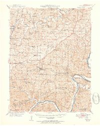
 1955 Jefferson City1967 Print · USGSCentral Missouri in the mid-fifties is defined by the winding Missouri River and the expanding reach of Lake of the Ozarks. Researchers can trace the rail corridors of the Missouri Pacific or locate the early footprint of Whiteman AFB and Jefferson City.4 unique versions available
 - 1958 Map of Jefferson City
 1958 Jefferson City1958 Print · USGSCentral Missouri in the late fifties shows a region transforming through the growth of Whiteman Air Force Base and the Lake of the Ozarks. Researchers can trace rail lines like the Missouri Pacific or find family roots at Enloe Cemetery and Mount Pleasant Cem.
 - 1959 Map of Jefferson City
 1959 Jefferson City1959 Print · USGSCentral Missouri is captured during the mid-fifties as the river economy and rail networks like the Missouri Pacific met the rise of the automobile. Local researchers can trace family landmarks and rural infrastructure from the Lake of the Ozarks up to Providence Cemetery and Knob Noster State Park.
 - 1962 Map of Jefferson City NW, 1982 Print
 1962 Jefferson City NW1982 Print · USGSCallaway County and the northern banks of the Missouri River are shown here in the early sixties, as residential growth reached toward the university's research lands. Genealogists can locate family burial sites like Meng Cem and Wallace Cem or trace the early paths of the Missouri-Kansas-Texas railroad.
 - 1967 Map of Osage City, 1968 Print
 1967 Osage City1968 Print · USGSMid-Missouri river life and rail transit converge in the late sixties at the meeting of the Missouri River and Osage River. Researchers can trace the heritage of Osage City and Taos, or locate family sites like St Xaviers Cem and Link Cem.4 unique versions available
 - 1967 Map of Jefferson City, 1968 Print
 1967 Jefferson City1968 Print · USGSJefferson City and the Missouri River corridor are captured in the late 1960s, showing the capital's expansion and its deep-rooted rail infrastructure. Researchers can locate specific institutional sites like the State Penitentiary, Lincoln University, and several historic burying grounds such as St Peters Cem.4 unique versions available
 - 1968 Map of Lohman, 1971 Print
 1968 Lohman1971 Print · USGSCole County hill country at the end of the sixties shows a transition from quiet agricultural roots to modern recreation and expansion. Genealogists can trace family heritage at Old Catholic Cem, St Pauls Ch, and the rural crossroads of Lohman.3 unique versions available
 - 1969 Map of Russellville, 1971 Print
 1969 Russellville1971 Print · USGSMid-century Missouri life unfolds along the Moniteau and Cole County line, where rail corridors and creek bottoms shaped the local landscape. Researchers can locate family heritage sites like Enloe Cem and Cole Spring Ch or trace the Old Railroad Grade.
 - 1969 Map of Hartsburg, 1971 Print
 1969 Hartsburg1971 Print · USGSMid-Missouri river life in the late sixties is documented here as railroads still traced the winding banks of the Missouri River. Genealogists and local researchers can locate old community landmarks like Bonds Chapel, Kings Chapel, and the State Auxiliary Prison.2 unique versions available
 - 1969 Map of Jefferson City NW, 1971 Print
 1969 Jefferson City NW1971 Print · USGSCallaway and Boone counties meet along the winding Cedar Creek in the late sixties, just north of the state capital. Researchers can trace rural lineages through the State Prison Farm, Holts Summit, and several country cemeteries like Shelley Cem.3 unique versions available
 - 1969 Map of Centertown NW, 1971 Print
 1969 Centertown NW1971 Print · USGSMoniteau County at the end of the sixties reveals a landscape of river-bottom farming and railroad towns. Genealogists and local historians can trace the foundations of Sandy Hook and Centertown, while locating rural landmarks like Shiloh Ch and the Indian Mounds.
 - 1980 Map of Jefferson City, 1981 Print
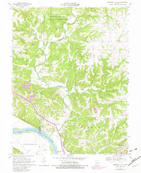
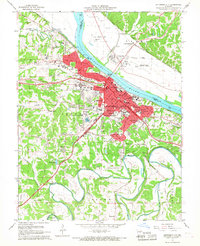
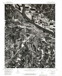 1980 Jefferson City1981 Print · USGSJefferson City and the Missouri River valley are captured in this 1980 orthophoto just as the capital's suburban footprint was expanding. Researchers can trace the industrial riverfront near the Capitol or locate outlying communities like Cole Junction and Wardsville.
 - 1982 Map of Jefferson City, 1983 Print
 1982 Jefferson City1983 Print · USGSMid-Missouri in the early eighties shows the corridor between Columbia and Jefferson City during a period of modern growth. Genealogists and historians can trace the Missouri Pacific Railroad route, family plots at Memorial Park Cem, and landmarks like Osage City and Lupus.
 - 1983 Map of Lake Of The Ozarks, 1984 Print
 1983 Lake Of The Ozarks1984 Print · USGSThe Lake of the Ozarks region in the early eighties shows a landscape of deep river bends and growing recreation. Genealogists can trace family names and small settlements from Versailles to Meta and locate old mining sites like Tiff Mine.
Showing maps 1-25 of 32
Top cities of Cole County
- Jefferson City historical maps
- Wardsville historical maps
- Taos historical maps
- Russellville historical maps
- Centertown historical maps
- Lohman historical maps
Frequently asked questions
- What are the different types of historical maps available for Cole County?
- What is the oldest map of Cole County?
- Where can I purchase historical maps of Cole County for my home or office?
- Where can I download high-res historical maps of Cole County?
- Are there historical topographic maps available for Cole County?
- Is there historical aerial imagery available for Cole County?
- Where are historical maps of Cole County sourced from?