1900s (20th Century) Maps of Cooper County, Missouri
Explore 38 historic maps of Cooper County from the 1900s (20th Century). These maps offer a rare glimpse into what life looked like during the 1900s — showing old roads, neighborhoods, homes, and landmarks that have changed or disappeared over time.
Whether you're researching your family's past, planning a metal detecting trip, or studying how Cooper County's landscape evolved across the 1900s, these high-resolution maps are a powerful tool for exploring the history of this region.
- Focus on a specific era: All maps on this page are from the 1900s, giving you a focused view of this time period.
- See what’s changed: Compare century-old streets, trails, and buildings to today's modern landscape using overlays and satellite layers.
- Research with precision: Use these maps for genealogy, historical research, land use analysis, or educational projects.
- View, download, or print: Maps are fully viewable online in high resolution, and can be downloaded or printed for your own records.
Start exploring Cooper County's history through authentic maps from the 1900s. This is your window into the past.
Cooper County, MO maps
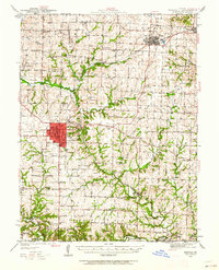
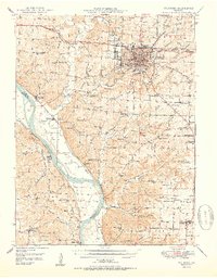
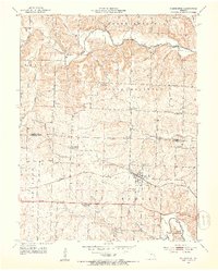
(38)- 1901 Map of Marshall
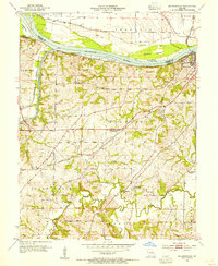
 1901 Marshall1901 Print · USGSCentral Missouri thrives along the river and rail lines at the turn of the century. Trace the early footprints of Marshall and Slater, or locate long-standing river landings and rural stations like Miami Station, Malta Bend, and Laynesville.5 unique versions available
 - 1940 Map of Marshall, 1962 Print
 1940 Marshall1962 Print · USGSSaline County in the late Depression era shows a landscape of small crossroads communities and family-named schools. Genealogists can trace rural roots at Bucksnort Sch, Missouri Valley College, and family burial grounds like Sappington Cem.
 - 1944 Map of Marshall
 1944 Marshall1944 Print · USGSSaline County centered on Marshall in the 1940s is a landscape of rural schools and intersecting rail lines. Genealogists can trace family roots through dozens of named sites like Sunset Hill Cem, Sulphur Springs Sch, and Blue Lick Springs.2 unique versions available
 - 1947 Map of Glasgow
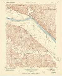
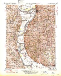 1947 Glasgow1947 Print · USGSThe Missouri River bottomlands in the mid-1940s reveal a landscape of shifting channels and established river towns. You can trace early settlement patterns through numerous rural landmarks like Sappington Cem, Boonesboro, and Farmers High Sch.2 unique versions available
 - 1947 Map of Jefferson City, 1949 Print
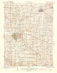
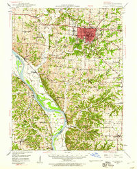
 1947 Jefferson City1949 Print · USGSCentral Missouri and the northern Ozarks come into focus in this late 1940s survey of the river-and-rail landscape. Genealogists and historians can trace the growth of Jefferson City and Sedalia or locate family roots near Bagnell Dam and the Lake of the Ozarks.
 - 1948 Map of Columbia, 1960 Print
 1948 Columbia1960 Print · USGSMid-century Boone County is captured here just as the educational and agricultural landscape began its post-war transition. Genealogists can trace family landmarks like Sugar Grove Ch and Vaughter Sch or follow the Missouri Pacific along the Missouri River.2 unique versions available
 - 1950 Map of Columbia
 1950 Columbia1950 Print · USGSMid-century Columbia and the Missouri River bottoms are captured here during a period of steady institutional and rail-driven growth. Genealogists and researchers can locate numerous country schools and churches like Mt Zion Ch, Huntsdale, and Valley Springs Sch.2 unique versions available
 - 1952 Map of Rocheport, 1953 Print
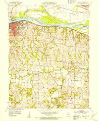
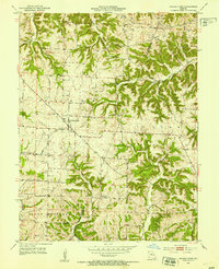
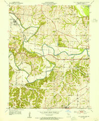
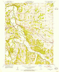
 1952 Rocheport1953 Print · USGSThe river bluffs of Boone and Cooper County come alive in the early fifties, showing the vital junctions of the Missouri River and two major rail lines. Researchers can trace the layout of Rocheport, locate family sites like Gooch Mill, or find old rural landmarks like Highland Sch and Copp Chapel.4 unique versions available
 - 1952 Map of Boonville, 1953 Print
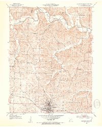
 1952 Boonville1953 Print · USGSBoonville and the Missouri River valley are captured here in the early fifties during a period of shifting rural school populations. Researchers can trace institutional footprints like the Kemper Military Sch or find family history at Walnut Grove Cem and Clarks Fork.3 unique versions available
 - 1952 Map of Tipton, 1953 Print
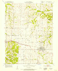 1952 Tipton1953 Print · USGSTipton and Syracuse sit at the junction of Cooper, Morgan, and Moniteau counties during the early fifties rail era. Researchers can trace the sprawling campus of the State Industrial Home for Girls or locate several decommissioned schools like Glendale Sch.3 unique versions available
 - 1952 Map of Clarksburg, 1953 Print
 1952 Clarksburg1953 Print · USGSMoniteau County's rural character and post-war transitions are on full display in the early fifties, centered on the Clarksburg rail stop. Genealogists can trace family landmarks like Sappington Cem and several closed schoolhouses, including Gill Sch.3 unique versions available
 - 1952 Map of Prairie Home, 1953 Print
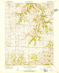
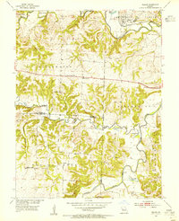
 1952 Prairie Home1953 Print · USGSCooper County agriculture and rural life are preserved here in the early fifties, as the era of the one-room schoolhouse began to fade. Trace local family history through mapped landmarks like Providence Cem, St Peters Ch, and the defunct Cedron Sch.3 unique versions available
 - 1952 Map of California North, 1953 Print
 1952 California North1953 Print · USGSIn the early 1950s, the area north of California, Missouri, was a landscape of small family farms and rural schoolhouses. Genealogists can trace family roots through several private burial grounds like Strickfaden Cem and identify local landmarks like the Old Salem Ch.4 unique versions available
 - 1952 Map of Lone Elm, 1954 Print
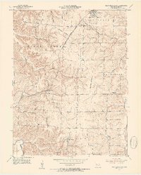
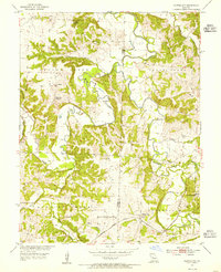
 1952 Lone Elm1954 Print · USGSMid-century Cooper County is captured here at a time when small rural settlements and family cemeteries still defined the local landscape. Researchers can locate Jefferson Sch, the Oil Tank Pumping Station, and community hubs like Lone Elm or Pisgah.2 unique versions available
 - 1953 Map of Moberly
 1953 Moberly1953 Print · USGSMid-century north-central Missouri is documented here as a bustling intersection of river commerce and heavy rail. Researchers can trace historic family-named landmarks and transport hubs from the Missouri River corridor to the rail yards of Moberly, Chillicothe, and Macon.
 - 1953 Map of Billingsville, 1954 Print
 1953 Billingsville1954 Print · USGSMid-century Cooper County revolves around the convergence of the Missouri and Lamine rivers and a busy rail network. Genealogists can trace family footprints at Pheasant Hill Cem or locate rural landmarks like Billingsville Sch and Lamine.3 unique versions available
 - 1953 Map of Pilot Grove North, 1954 Print
 1953 Pilot Grove North1954 Print · USGSMid-century Cooper County centers on the convergence of the Lamine and Blackwater rivers during a time of rural transition. Genealogists can trace family sites like the Herndon Cem, St Martin Cem, and the now-abandoned Chouteau Sch (Abandoned).2 unique versions available
 - 1953 Map of Pilot Grove South, 1954 Print
 1953 Pilot Grove South1954 Print · USGSCooper County agriculture and rail life are captured here in the early fifties, centered on the KANSAS MISSOURI TEXAS line. Genealogists can locate family landmarks like St Pauls Ch, Pleasant Green, and the rural New Lebanon settlement.3 unique versions available
 - 1953 Map of Bunceton, 1954 Print
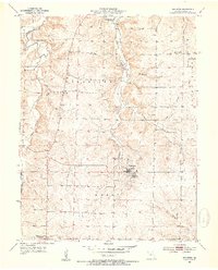 1953 Bunceton1954 Print · USGSMid-century Cooper County comes to life in this survey of rural Missouri's agricultural heartland. Genealogists and local historians can trace family roots at the Masonic Cem, locate the village of Speed, or find the site of the Bethlehem Sch.3 unique versions available
 - 1953 Map of Otterville East, 1954 Print
 1953 Otterville East1954 Print · USGSMid-century Morgan and Cooper counties appear here as a landscape of rural townships and river valleys. Researchers can trace family history at Antioch Cem and Mt Olive Ch or follow the Missouri Pacific rail line through Otterville.3 unique versions available
 - 1953 Map of Nelson, 1955 Print
 1953 Nelson1955 Print · USGSMid-Missouri farming and river life are preserved here during the early fifties, where the Blackwater River and Lamine River meet. Researchers can locate vanished rural landmarks like Postal Sch, Millers Chapel, and the Raines Cemetery.2 unique versions available
 - 1953 Map of Clifton City, 1955 Print
 1953 Clifton City1955 Print · USGSThe Pettis and Cooper county line comes alive in the early fifties, centered on the railroad hub of Clifton City. Genealogists can trace family roots at St Josephs Cem, Lee Cem, and the sites of local schools like Scott Sch.2 unique versions available
 - 1954 Map of Jefferson City
 1954 Jefferson City1954 Print · USGSCentral Missouri in the early postwar years showcases a landscape defined by the winding Lake of the Ozarks and the state capital at Jefferson City. Researchers can trace the mid-century rail networks of the Missouri Pacific RR and locate rural communities like Tuscumbia, St Elizabeth, and St Anthony.2 unique versions available
 - 1954 Map of Moberly, 1969 Print
 1954 Moberly1969 Print · USGSMid-century Missouri is captured here during a period of transition for its river towns and rail hubs. Genealogists and historians can trace the paths of the Wabash railroad through Moberly or explore the riverside layout of Lexington and Brunswick.3 unique versions available
 - 1955 Map of Jefferson City, 1967 Print
 1955 Jefferson City1967 Print · USGSCentral Missouri in the mid-fifties is defined by the winding Missouri River and the expanding reach of Lake of the Ozarks. Researchers can trace the rail corridors of the Missouri Pacific or locate the early footprint of Whiteman AFB and Jefferson City.4 unique versions available
Showing maps 1-25 of 38
Top cities of Cooper County
- Boonville historical maps
- Pilot Grove historical maps
- Otterville historical maps
- Bunceton historical maps
- Windsor Place historical maps
- Prairie Home historical maps
See more
Frequently asked questions
- What are the different types of historical maps available for Cooper County?
- What is the oldest map of Cooper County?
- Where can I purchase historical maps of Cooper County for my home or office?
- Where can I download high-res historical maps of Cooper County?
- Are there historical topographic maps available for Cooper County?
- Is there historical aerial imagery available for Cooper County?
- Where are historical maps of Cooper County sourced from?