1970s Maps of Cooper County, Missouri
Explore 2 historic maps of Cooper County from the 1970s. These maps offer a rare glimpse into what life looked like during the 1970s — showing old roads, neighborhoods, homes, and landmarks that have changed or disappeared over time.
Whether you're researching your family's past, planning a metal detecting trip, or studying how Cooper County's landscape evolved across the 1970s, these high-resolution maps are a powerful tool for exploring the history of this region.
- Focus on a specific era: All maps on this page are from the 1970s, giving you a focused view of this time period.
- See what’s changed: Compare century-old streets, trails, and buildings to today's modern landscape using overlays and satellite layers.
- Research with precision: Use these maps for genealogy, historical research, land use analysis, or educational projects.
- View, download, or print: Maps are fully viewable online in high resolution, and can be downloaded or printed for your own records.
Start exploring Cooper County's history through authentic maps from the 1970s. This is your window into the past.
Cooper County, MO maps
(2)- 1971 Map of Arrow Rock, 1973 Print
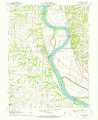 1971 Arrow Rock1973 Print · USGSIn the early seventies, the Missouri River bluffs near the Saline and Howard county lines retained their rural character. Researchers can trace historic riverfront communities like Arrow Rock and Lisbon, or locate family sites such as Rose Hill Cem and Townsend Cem.2 unique versions available
 - 1971 Map of Napton, 1973 Print
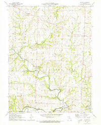 1971 Napton1973 Print · USGSSaline County’s river-carved landscape is shown here in the early seventies, centered on the meeting of the Blackwater River and Salt Fork. Researchers can trace old family roots and community sites at Sappington Cem, Smith Chapel, and the settlement of Napton.
End of results
Showing maps 1-2 of 2
Top cities of Cooper County
- Boonville historical maps
- Pilot Grove historical maps
- Otterville historical maps
- Bunceton historical maps
- Windsor Place historical maps
- Prairie Home historical maps
See more
Frequently asked questions
- What are the different types of historical maps available for Cooper County?
- What is the oldest map of Cooper County?
- Where can I purchase historical maps of Cooper County for my home or office?
- Where can I download high-res historical maps of Cooper County?
- Are there historical topographic maps available for Cooper County?
- Is there historical aerial imagery available for Cooper County?
- Where are historical maps of Cooper County sourced from?