1930s Maps of Corkery, Missouri
Explore 2 historic maps of Corkery from the 1930s. These maps offer a rare glimpse into what life looked like during the 1930s — showing old roads, neighborhoods, homes, and landmarks that have changed or disappeared over time.
Whether you're researching your family's past, planning a metal detecting trip, or studying how Corkery's landscape evolved across the 1930s, these high-resolution maps are a powerful tool for exploring the history of this region.
- Focus on a specific era: All maps on this page are from the 1930s, giving you a focused view of this time period.
- See what’s changed: Compare century-old streets, trails, and buildings to today's modern landscape using overlays and satellite layers.
- Research with precision: Use these maps for genealogy, historical research, land use analysis, or educational projects.
- View, download, or print: Maps are fully viewable online in high resolution, and can be downloaded or printed for your own records.
Start exploring Corkery's history through authentic maps from the 1930s. This is your window into the past.
Corkery, MO maps
(2)- 1934 Map of Macks Creek
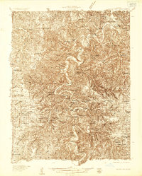 1934 Macks Creek1934 Print · USGSIn the central Ozarks during the 1930s, the rugged river valleys supported a landscape of isolated homesteads and country schoolhouses. Genealogists can locate family landmarks like Laughlin Cem, Johnston Castle, and the Tunnel Dam along the Niangua River.4 unique versions available
 - 1939 Map of Macks Creek
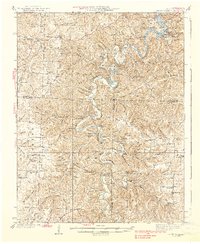 1939 Macks Creek1939 Print · USGSThe Niangua River valley in the late 1930s reveals a landscape of river crossings and early Ozark tourism. Researchers can trace ancestral locations through numerous rural school sites like Barkley Sch or find landmarks like Hahatonka Castle and Tunnel Dam.2 unique versions available
End of results
Showing maps 1-2 of 2
Top cities near Corkery
- Lebanon historical maps
- Camdenton historical maps
- Buffalo historical maps
- Macks Creek historical maps
- Evergreen historical maps
- Caffeyville historical maps
Frequently asked questions
- What are the different types of historical maps available for Corkery?
- What is the oldest map of Corkery?
- Where can I purchase historical maps of Corkery for my home or office?
- Where can I download high-res historical maps of Corkery?
- Are there historical topographic maps available for Corkery?
- Is there historical aerial imagery available for Corkery?
- Where are historical maps of Corkery sourced from?