1970s Maps of Dent County, Missouri
Explore 3 historic maps of Dent County from the 1970s. These maps offer a rare glimpse into what life looked like during the 1970s — showing old roads, neighborhoods, homes, and landmarks that have changed or disappeared over time.
Whether you're researching your family's past, planning a metal detecting trip, or studying how Dent County's landscape evolved across the 1970s, these high-resolution maps are a powerful tool for exploring the history of this region.
- Focus on a specific era: All maps on this page are from the 1970s, giving you a focused view of this time period.
- See what’s changed: Compare century-old streets, trails, and buildings to today's modern landscape using overlays and satellite layers.
- Research with precision: Use these maps for genealogy, historical research, land use analysis, or educational projects.
- View, download, or print: Maps are fully viewable online in high resolution, and can be downloaded or printed for your own records.
Start exploring Dent County's history through authentic maps from the 1970s. This is your window into the past.
Dent County, MO maps
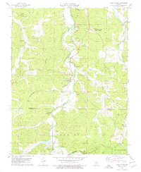
(3)- 1971 Map of Rolla
 1971 Rolla1971 Print · USGSThe Missouri Ozarks are captured here during the early seventies, showing a landscape of deep river valleys and industrial mining towns. Researchers can trace historic lead mining operations at St Joseph Mines and locate rural landmarks like Viburnum and the Galveston Trail.
 - 1978 Map of Cook Station, 1979 Print
 1978 Cook Station1979 Print · USGSThe Meramec River valley comes into focus in the late 1970s, showing a landscape of small rail settlements and lingering industrial sites. Family historians can trace ancestral sites at Cook Station and Wesco, alongside landmarks like Charcoal Ovens and the Gorman Cem.
 - 1978 Map of Cherryville, 1979 Print
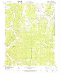 1978 Cherryville1979 Print · USGSIn the late seventies, the Ozark hills around Cherryville were a patchwork of national forest and historic mining sites. Trace family roots at New Home Ch or explore old industrial corridors along the Old Railroad Grade and numerous Iron Pits.
End of results
Showing maps 1-3 of 3
Top cities of Dent County
Frequently asked questions
- What are the different types of historical maps available for Dent County?
- What is the oldest map of Dent County?
- Where can I purchase historical maps of Dent County for my home or office?
- Where can I download high-res historical maps of Dent County?
- Are there historical topographic maps available for Dent County?
- Is there historical aerial imagery available for Dent County?
- Where are historical maps of Dent County sourced from?