1990s Maps of Dent County, Missouri
Explore 9 historic maps of Dent County from the 1990s. These maps offer a rare glimpse into what life looked like during the 1990s — showing old roads, neighborhoods, homes, and landmarks that have changed or disappeared over time.
Whether you're researching your family's past, planning a metal detecting trip, or studying how Dent County's landscape evolved across the 1990s, these high-resolution maps are a powerful tool for exploring the history of this region.
- Focus on a specific era: All maps on this page are from the 1990s, giving you a focused view of this time period.
- See what’s changed: Compare century-old streets, trails, and buildings to today's modern landscape using overlays and satellite layers.
- Research with precision: Use these maps for genealogy, historical research, land use analysis, or educational projects.
- View, download, or print: Maps are fully viewable online in high resolution, and can be downloaded or printed for your own records.
Start exploring Dent County's history through authentic maps from the 1990s. This is your window into the past.
Dent County, MO maps
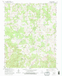
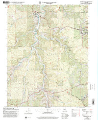
(9)- 1992 Map of Anutt, 1995 Print
 1992 Anutt1995 Print · USGSDent and Phelps Counties remained a landscape of dispersed homesteads and hollows during the early 1990s. Genealogists can trace family heritage through numerous burial grounds like Headrick Cem and Thorpe Cem or find local landmarks such as Bethel Ch.
 - 1992 Map of Rhyse, 1995 Print
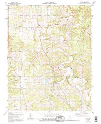
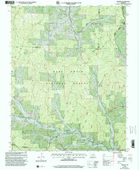
 1992 Rhyse1995 Print · USGSThe rural Ozark highlands of Dent County are captured here during the 1990s, revealing a landscape of family cemeteries and remote hollows. Genealogists and local historians can trace legacy sites like Robnett Cem or find the Lookout Tower Zion near the Montauk State Public Hunting Area.
 - 1992 Map of Lecoma, 1995 Print
 1992 Lecoma1995 Print · USGSThe Missouri Ozarks are captured here during the 1990s, revealing a landscape of winding ridges and deep cave systems. Researchers can trace rural settlement patterns through sites like Lecoma, Elk Prairie Ch, and the historic Charcoal Ovens.
 - 1999 Map of Bunker, 2002 Print
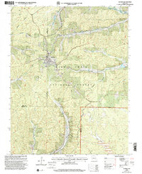 1999 Bunker2002 Print · USGSThe community of Bunker sits at the meeting point of three counties in the late nineties, surrounded by deep timber lands. Trace family sites at Estep Cem and Parks Cem, or locate landmarks like the Sawmill and the unique Turner Natural Bridge.
 - 1999 Map of Stone Hill, 2002 Print
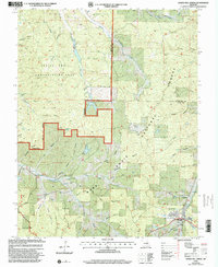
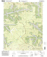 1999 Stone Hill2002 Print · USGSThe Dent and Reynolds county line near the Meramec River is shown here at the turn of the millennium, following decades of forest management and rural change. Researchers can trace the heritage of small settlements and industries through the Scotia Iron Mine, the Stone Hill Ch, and Howes Mill.
 - 1999 Map of Viburnum West, 2002 Print
 1999 Viburnum West2002 Print · USGSThe Missouri Ozarks are captured here at the close of the millennium, showing a landscape defined by federal forest lands and the lead industry. Researchers can find old family burial grounds like Maple Grove Cem, the site of Richards Charcoal Kilns, and the historic Dillard Mill State Historical Site.
 - 1999 Map of Greeley, 2002 Print
 1999 Greeley2002 Print · USGSThe Missouri Ozarks during the late twentieth century reveal a landscape where forestry and heavy industry meet. Genealogists and historians can trace the foundations of Greeley and Crossville or locate remote sites like the Charcoal Kilns and Barton Cem.
 - 1999 Map of Howes Mill Spring, 2002 Print
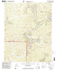
 1999 Howes Mill Spring2002 Print · USGSDent County and Crawford County are shown in the late nineties, documenting a landscape of remote hollows and high Ozark ridges. Genealogists and researchers can trace family landmarks like Hutson-Walker Cem, Bowers Cem, and the abandoned fish hatcheries near Howes Mill Spring.
 - 1999 Map of Loggers Lake, 2002 Print
 1999 Loggers Lake2002 Print · USGSThe Ozark Highlands on the Dent and Shannon County border come alive in the late nineties, showcasing a landscape of managed timber and hidden hollows. Genealogists can trace family landmarks like Chatman Cem, Delmar Cem, and the waters of Aunt Sal Creek.
End of results
Showing maps 1-9 of 9
Top cities of Dent County
Frequently asked questions
- What are the different types of historical maps available for Dent County?
- What is the oldest map of Dent County?
- Where can I purchase historical maps of Dent County for my home or office?
- Where can I download high-res historical maps of Dent County?
- Are there historical topographic maps available for Dent County?
- Is there historical aerial imagery available for Dent County?
- Where are historical maps of Dent County sourced from?