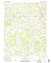
1992 Map of Anutt
USGS Topo · Published 1995About this map
Anutt sits at the center of this rural landscape, which spans the boundary of Dent Co and Phelps Co. The terrain is defined by a dense network of valleys such as Elk Hollow and Price Hollow, draining toward the Prong Dry Fork and Dry Fork. This late-twentieth-century study reveals a community deeply rooted in its local geography, with numerous family-named cemeteries and small churches scattered across the uplands. Genealogists will find a high concentration of burial sites, including Bingham Cem, Karns Cem, and Edgar Cem. The presence of the Full Gospel Mission Ch and Bethel Ch further underscores the dispersed nature of settlement in this part of Missouri. Agricultural and local industry is represented by the small community at Springs and an unnamed Mine located north of Graves.
Find a feature on this map
32 named features on this map. Tap any name to fly to it.
Don’t see what you’re looking for? This feature index may not catch every label — zoom into the map to look around manually.
Map Details
Editions of this 1992 Anutt Map
This is the sole edition of this map. No revisions or reprints were ever made.
Other maps of this area

1912 · Rolla
USGS Topo · 1:62,500

1928 · Meramec Spring
USGS Topo · 1:62,500

1937 · Edgar Springs
USGS Topo · 1:48,000

1941 · Salem
USGS Topo · 1:62,500

1945 · Salem
USGS Topo · 1:62,500

1945 · Edgar Springs
USGS Topo · 1:62,500

1949 · Rolla
USGS Topo · 1:250,000

1949 · Meramec Spring
USGS Topo · 1:62,500
1950 · Yancy Mills
USGS Topo · 1:24,000
1951 · Yancy Mills
USGS Topo · 1:24,000