
1945 Map of Edgar Springs
USGS Topo · Published 1945About this map
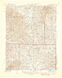
Edgar Springs serves as a central hub in this mid-century topographic survey, positioned at the convergence of rugged ridges and deep hollows across Phelps and Texas counties. The landscape is defined by the drainage of Spring Creek and Little Piney Creek, where the local economy and social life are marked by a dense network of country schools and family burial grounds. Notable institutional presence includes the U S Forest Service Nursery and the Blooming Rose CCC Camp (Abandoned), the latter reflecting the transitioning labor and conservation landscape of the era. Genealogists will find high density in rural markers like Bethlehem Sch & Pray Cem, Shafer Cem, and the Mathis Sch. The topography is intricate, characterized by named landforms such as Tie Ridge and Solomon Hollow, illustrating a time when even small geographic features held specific local importance for woodcutting and agriculture.
Find a feature on this map
73 named features on this map. Tap any name to fly to it.
Don’t see what you’re looking for? This feature index may not catch every label — zoom into the map to look around manually.
Map Details
Editions of this 1945 Edgar Springs Map
2 editions found
Other maps of this area

1912 · Rolla
USGS Topo · 1:62,500

1928 · Meramec Spring
USGS Topo · 1:62,500

1932 · Cedar Grove
USGS Topo · 1:48,000

1936 · Waynesville
USGS Topo · 1:48,000

1937 · Edgar Springs
USGS Topo · 1:48,000

1941 · Big Piney
USGS Topo · 1:62,500

1941 · Salem
USGS Topo · 1:62,500

1941 · Bado
USGS Topo · 1:62,500

1942 · Waynesville
USGS Topo · 1:62,500

1943 · Big Piney
USGS Topo · 1:62,500