
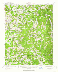
1949 Map of Meramec Spring
USGS Topo · Published 1957About this map
St Louis - San Francisco railroad tracks cut across the northern landscape near St James, where the Ozark terrain begins its descent toward the winding Meramec River. This mid-century survey reveals a dense network of rural infrastructure, from the industrial Bronson Mine and Benton Creek Mine to the vital crossings at Morrison Ford and Smallwood Ford. The land is dotted with family names and community anchors, including over twenty neighborhood schoolhouses like Flat Grove School and Wishon School, and historic congregations at Belview Church and Mt Pisgah Church. These details underscore the self-sufficient nature of Phelps and Dent Counties during the late 1940s. Natural landmarks such as Meramec Spring and a Natural Bridge punctuate the ridges and hollows, while settlements like Dillon, Lecoma, and De Camp serve as local hubs for the surrounding farm and timber lands.
Find a feature on this map
75 named features on this map. Tap any name to fly to it.
Don’t see what you’re looking for? This feature index may not catch every label — zoom into the map to look around manually.
Map Details
Editions of this 1949 Meramec Spring Map
2 editions found
Other maps of this area

1903 · Sullivan
USGS Topo · 1:125,000

1912 · Rolla
USGS Topo · 1:62,500

1928 · Meramec Spring
USGS Topo · 1:62,500

1932 · Steelville
USGS Topo · 1:48,000

1933 · Steelville
USGS Topo · 1:62,500

1934 · Redbird
USGS Topo · 1:62,500

1937 · Steelville
USGS Topo · 1:62,500

1937 · Edgar Springs
USGS Topo · 1:48,000

1937 · Vienna
USGS Topo · 1:62,500

1938 · Redbird
USGS Topo · 1:62,500