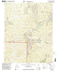
1999 Map of Loggers Lake
USGS Topo · Published 2002About this map
The Ozark plateau within the Mark Twain National Forest is defined by a dense network of hollows and springs as it appeared at the close of the twentieth century. Water drainage patterns dominate the landscape, with Sinking Creek and Little Sinking Creek cutting through the terrain alongside family-named drainages like Thompson Hollow and Bacon Hollow. For genealogists, the map preserves the locations of several remote burial grounds, including Chatman Cem and Hanong Cem, which are tucked away near these drainages.
Find a feature on this map
55 named features on this map. Tap any name to fly to it.
Don’t see what you’re looking for? This feature index may not catch every label — zoom into the map to look around manually.
Map Details
Editions of this 1999 Loggers Lake Map
This is the sole edition of this map. No revisions or reprints were ever made.
Other maps of this area

1941 · Stone Hill
USGS Topo · 1:62,500

1943 · Boss
USGS Topo · 1:62,500

1944 · Corridon
USGS Topo · 1:62,500

1945 · Stone Hill
USGS Topo · 1:62,500

1945 · Round Spring
USGS Topo · 1:62,500

1946 · Boss
USGS Topo · 1:62,500

1947 · Sinkin
USGS Topo · 1:48,000

1947 · Corridon
USGS Topo · 1:62,500

1949 · Round Spring
USGS Topo · 1:62,500

1949 · Rolla
USGS Topo · 1:250,000