1950s Maps of Dunklin County, Missouri
Explore 18 historic maps of Dunklin County from the 1950s. These maps offer a rare glimpse into what life looked like during the 1950s — showing old roads, neighborhoods, homes, and landmarks that have changed or disappeared over time.
Whether you're researching your family's past, planning a metal detecting trip, or studying how Dunklin County's landscape evolved across the 1950s, these high-resolution maps are a powerful tool for exploring the history of this region.
- Focus on a specific era: All maps on this page are from the 1950s, giving you a focused view of this time period.
- See what’s changed: Compare century-old streets, trails, and buildings to today's modern landscape using overlays and satellite layers.
- Research with precision: Use these maps for genealogy, historical research, land use analysis, or educational projects.
- View, download, or print: Maps are fully viewable online in high resolution, and can be downloaded or printed for your own records.
Start exploring Dunklin County's history through authentic maps from the 1950s. This is your window into the past.
Dunklin County, MO maps
(18)- 1953 Map of Memphis, 1966 Print
 1953 Memphis1966 Print · USGSEastern Arkansas and the Memphis riverfront are shown here during the mid-century period of regional growth and river management. Local historians can trace the paths of the Chicago Rock Island & Pacific RR through Forrest City or locate river landmarks like President's Island.3 unique versions available
 - 1955 Map of Pascola
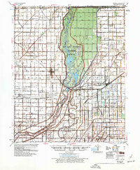
 1955 Pascola1955 Print · USGSThe Missouri Bootheel in the mid-fifties reveals a landscape defined by an extensive drainage system and the St Louis San Francisco rail line. Researchers can trace rural life through sites like the Delmore Labor Home, Sumach Ch & Cem, and the Gideon Memorial Airport.
 - 1955 Map of Hayti
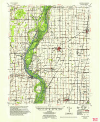
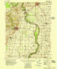
 1955 Hayti1955 Print · USGSThe Missouri Bootheel comes into focus during the mid-fifties, showing a landscape defined by drainage ditches and rail-centered commerce. Researchers can find numerous rural landmarks like the Canady Switch Sch, Zion Rock Ch, and the County Farm Cem.
 - 1955 Map of Blytheville
 1955 Blytheville1955 Print · USGSMid-century Mississippi County, Arkansas, is shown here as a landscape of reclaimed delta land and bustling rail towns. Genealogists can trace family names through rural landmarks like Number Nine, Promised Land, and the O'Donald Bend Community.
 - 1956 Map of Valley Ridge
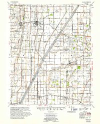
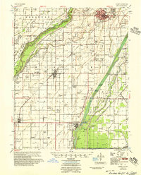
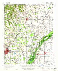
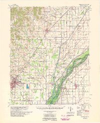
 1956 Valley Ridge1956 Print · USGSDunklin and Butler counties in the mid-fifties show a landscape shaped by river transport and extensive drainage projects. Genealogists can locate many rural social hubs like Depoyster Ch & Sch, Higginbothams Ferry, and the St Louis Southwestern Railroad.
 - 1956 Map of Leachville
 1956 Leachville1956 Print · USGSThe Arkansas-Missouri borderlands in the mid-1950s show a region shaped by major drainage projects and the railroad economy. Genealogists and historians can trace family locations near Leachville, Black Oak, and several country schools like Milligan Ridge Sch.2 unique versions available
 - 1956 Map of Kennett
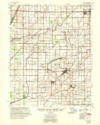
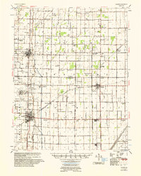
 1956 Kennett1956 Print · USGSThe Missouri Bootheel's agricultural and drainage transformation is on full display in the mid-fifties. Genealogists can trace family roots through numerous rural sites like Silverdale Ch & Cem, Harkeys Chapel, and the Oak Ridge Cem near Kennett.2 unique versions available
 - 1956 Map of Manila
 1956 Manila1956 Print · USGSNortheastern Arkansas is seen here during a period of massive agricultural drainage and wetland management in the mid-fifties. Genealogists and historians can trace numerous rural landmarks, from McFerrin Plantation and Sunnyland Ch to the remote Little Green Sch.3 unique versions available
 - 1956 Map of Memphis
 1956 Memphis1956 Print · USGSThe Mississippi Delta and the bluffs of West Tennessee meet in the mid-fifties, showing a landscape defined by massive river systems and rail hubs. Researchers can trace the path of Crowleys Ridge or locate vanished river landings near Centennial Island and Island No 35.
 - 1956 Map of Piggott
 1956 Piggott1956 Print · USGSThe Arkansas-Missouri borderlands in the mid-fifties were defined by the shifting loops of the St Francis River and the arrival of modern flood control. Researchers can locate vanished rural landmarks like Holly Island Community, Wrights Chapel, and the Meander Line of the old river channel.2 unique versions available
 - 1956 Map of Malden
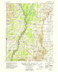
 1956 Malden1956 Print · USGSThe Missouri bootheel in the mid-1950s reveals a highly engineered landscape where drainage ditches and rail lines shaped every town and farm. Genealogists can locate family landmarks like Poplin Sch & Cem, Stones Chapel Cem, and the Malden Air Force Base.
 - 1956 Map of Dyersburg, 1960 Print
 1956 Dyersburg1960 Print · USGSThe Four Rivers region comes alive in the mid-fifties, capturing the intricate borderlands of Tennessee, Kentucky, and Missouri. Genealogists and historians can trace the rail-and-river networks connecting Dyersburg, Caruthersville, and the shoreline of Reelfoot Lake.4 unique versions available
 - 1956 Map of Blytheville, 1964 Print
 1956 Blytheville1964 Print · USGSWest Tennessee and the Arkansas Delta come alive in this mid-century survey of the river-and-rail corridor connecting Memphis to Jackson. Genealogists and historians can trace the rail lines of the Louisville and Nashville RR and locate landmarks like Western State Hospital or Fort Pillow State Prison Farm.2 unique versions available
 - 1957 Map of Poplar Bluff, 1968 Print
 1957 Poplar Bluff1968 Print · USGSThe Missouri-Arkansas border region is captured here as the timber and rail industries shaped the Ozark foothills. Genealogists and historians can trace the Missouri Pacific Railroad through river towns like Pocahontas, Greenville, and Van Buren.3 unique versions available
 - 1958 Map of Marmaduke, 1962 Print
 1958 Marmaduke1962 Print · USGSThe Arkansas-Missouri borderlands come alive in this mid-century survey of the St. Francis River basin and the agricultural landscape of Greene County. Genealogists and historians can trace family locations through numerous rural landmarks like Harveys Chapel Cem, Nutt Chapel, and the stops along the St Louis Southwestern RR.2 unique versions available
 - 1959 Map of Poplar Bluff
 1959 Poplar Bluff1959 Print · USGSThe Missouri Ozarks and Arkansas borderlands meet in this late 1950s study of the region's diverse terrain and rail-fed towns. Researchers can trace the path of the Missouri Pacific Railroad through Poplar Bluff or locate smaller settlements like Birch Tree and Myrtle.
 - 1959 Map of Blytheville
 1959 Blytheville1959 Print · USGSWest Tennessee and Northeast Arkansas meet along the river in the late fifties, during a period of steady industrial and agricultural growth. Genealogists can trace the rail corridors of the Illinois Central through Jackson or explore landmarks like Shiloh National Military Park and Fort Pillow State Prison.
 - 1959 Map of Marmaduke
 1959 Marmaduke1959 Print · USGSGreene County and the Missouri bootheel transition appear here in the late fifties, dominated by the rail-and-river economy. Researchers can trace rural lineages through dozen of landmarks like Old Liberty Cem, Alexander Sch, and the riverside settlement of Cardwell.
End of results
Showing maps 1-18 of 18
Top cities of Dunklin County
- Kennett historical maps
- Malden historical maps
- Campbell historical maps
- Senath historical maps
- Clarkton historical maps
- Cardwell historical maps
See more
Frequently asked questions
- What are the different types of historical maps available for Dunklin County?
- What is the oldest map of Dunklin County?
- Where can I purchase historical maps of Dunklin County for my home or office?
- Where can I download high-res historical maps of Dunklin County?
- Are there historical topographic maps available for Dunklin County?
- Is there historical aerial imagery available for Dunklin County?
- Where are historical maps of Dunklin County sourced from?