1970s Maps of Gasconade County, Missouri
Explore 8 historic maps of Gasconade County from the 1970s. These maps offer a rare glimpse into what life looked like during the 1970s — showing old roads, neighborhoods, homes, and landmarks that have changed or disappeared over time.
Whether you're researching your family's past, planning a metal detecting trip, or studying how Gasconade County's landscape evolved across the 1970s, these high-resolution maps are a powerful tool for exploring the history of this region.
- Focus on a specific era: All maps on this page are from the 1970s, giving you a focused view of this time period.
- See what’s changed: Compare century-old streets, trails, and buildings to today's modern landscape using overlays and satellite layers.
- Research with precision: Use these maps for genealogy, historical research, land use analysis, or educational projects.
- View, download, or print: Maps are fully viewable online in high resolution, and can be downloaded or printed for your own records.
Start exploring Gasconade County's history through authentic maps from the 1970s. This is your window into the past.
Gasconade County, MO maps
(8)- 1973 Map of Dissen, 1975 Print
 1973 Dissen1975 Print · USGSFranklin and Gasconade counties appear here during the early 1970s, showing a quiet landscape of agricultural homesteads and rural church parishes. Genealogists can trace family names through landmarks like Senate Grove Ch, Kohlbush Cem, and the village of Dissen.
 - 1973 Map of Swiss, 1975 Print
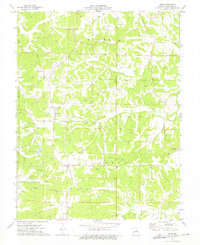 1973 Swiss1975 Print · USGSGasconade County settlement and industry are captured here in the early seventies, showing a landscape defined by small communities and clay mining. Researchers can trace family sites at Boesch Cem and Bieber Cem or locate old industrial Claypits near Swiss.
 - 1974 Map of Hermann, 1975 Print
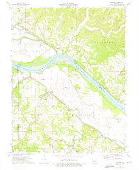
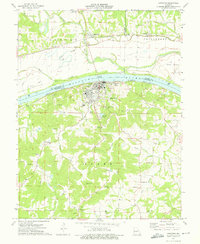 1974 Hermann1975 Print · USGSHermann and the Missouri River bottomlands are captured here in the mid-1970s, showcasing a landscape defined by levees, rail lines, and river islands. Genealogists can locate numerous family-named burial grounds including Poeschel Cem, Langendoerfer Cem, and Beckman Cem.2 unique versions available
 - 1974 Map of Gasconade, 1975 Print
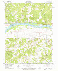
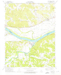 1974 Gasconade1975 Print · USGSThe confluence of the Missouri and Gasconade rivers defined this river-and-rail corridor in the mid-1970s. Researchers can trace family history through several rural burial sites like St Marcus Cem or locate old industrial claypits near Starkenburg.
 - 1974 Map of Berger, 1975 Print
 1974 Berger1975 Print · USGSFranklin and Gasconade counties are captured here in the mid-seventies, showing a landscape defined by the river and the rail. Genealogists and local historians can trace old family burial grounds like St Pauls Cem and Haid Cem, or locate rail stops in Berger and Etlah.
 - 1974 Map of Pershing, 1976 Print
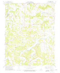
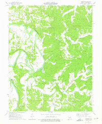 1974 Pershing1976 Print · USGSThe Gasconade River meanders through central Missouri during the mid-seventies, shaping a landscape of river-bend settlements and upland clay pits. Genealogists and local historians can locate family cemeteries and river crossings like Feigler Ferry, Krueger Ford, and St Johns Ch.
 - 1974 Map of Morrison, 1976 Print
 1974 Morrison1976 Print · USGSThe Missouri River and Gasconade River confluence area is captured here in the mid-seventies, showing a landscape defined by rail and river. Researchers can trace family history through numerous bluff-side burials like Schobe Cem and Good Hope Cem or locate old river stops at Portland and Bluffton.2 unique versions available
 - 1974 Map of Fredericksburg, 1976 Print
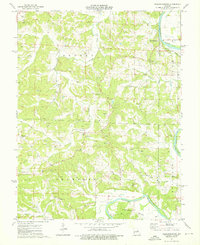 1974 Fredericksburg1976 Print · USGSThe Gasconade River valley in the mid-1970s remains a landscape of small river towns and active mineral extraction. Family historians can trace deep roots through local landmarks like Mint Hill, Salem Ch, and the Karschnick Cem near Mud Creek.
End of results
Showing maps 1-8 of 8
Top cities of Gasconade County
- Hermann historical maps
- Owensville historical maps
- Rosebud historical maps
- Gasconade historical maps
- Morrison historical maps
Frequently asked questions
- What are the different types of historical maps available for Gasconade County?
- What is the oldest map of Gasconade County?
- Where can I purchase historical maps of Gasconade County for my home or office?
- Where can I download high-res historical maps of Gasconade County?
- Are there historical topographic maps available for Gasconade County?
- Is there historical aerial imagery available for Gasconade County?
- Where are historical maps of Gasconade County sourced from?