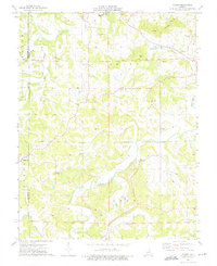
1973 Map of Dissen
USGS Topo · Published 1975About this map
Dissen and the surrounding rural communities of Franklin and Gasconade counties are captured in this mid-1970s survey, illustrating a landscape defined by small family settlements and numerous country burial grounds. The map reveals a high density of genealogical landmarks, including the Kohlbush Cem, Helling Cem, and Meyers Cem, alongside local centers of worship such as Senate Grove Ch and Stone Ch. The terrain transitions from the elevations of Etiah Knobs down to the winding waters of Big Berger Creek and Cedar Fork. Notable landmarks like Jacobs Well Cave and the Maria Vista Retreat suggest a mix of natural features and private institutions. Economic activity is limited to small-scale operations, evidenced by several scattered Quarry sites and a Claypit, while the settlement at Stony Hill marks the western edge of the quadrangle.
Find a feature on this map
32 named features on this map. Tap any name to fly to it.
Don’t see what you’re looking for? This feature index may not catch every label — zoom into the map to look around manually.
Map Details
Editions of this 1973 Dissen Map
This is the sole edition of this map. No revisions or reprints were ever made.
Other maps of this area

1890 · Hermann
USGS Topo · 1:125,000

1903 · Sullivan
USGS Topo · 1:125,000

1935 · Gerald
USGS Topo · 1:48,000

1936 · Hermann
USGS Topo · 1:48,000

1941 · Gerald
USGS Topo · 1:62,500

1942 · Hermann
USGS Topo · 1:62,500

1944 · Gerald
USGS Topo · 1:62,500

1945 · Hermann
USGS Topo · 1:62,500

1946 · Union
USGS Topo · 1:62,500

1948 · Union
USGS Topo · 1:62,500