1940s Maps of Willow Springs, Missouri
Explore 5 historic maps of Willow Springs from the 1940s. These maps offer a rare glimpse into what life looked like during the 1940s — showing old roads, neighborhoods, homes, and landmarks that have changed or disappeared over time.
Whether you're researching your family's past, planning a metal detecting trip, or studying how Willow Springs's landscape evolved across the 1940s, these high-resolution maps are a powerful tool for exploring the history of this region.
- Focus on a specific era: All maps on this page are from the 1940s, giving you a focused view of this time period.
- See what’s changed: Compare century-old streets, trails, and buildings to today's modern landscape using overlays and satellite layers.
- Research with precision: Use these maps for genealogy, historical research, land use analysis, or educational projects.
- View, download, or print: Maps are fully viewable online in high resolution, and can be downloaded or printed for your own records.
Start exploring Willow Springs's history through authentic maps from the 1940s. This is your window into the past.
Willow Springs, MO maps
(5)- 1945 Map of Willow Springs, 1954 Print
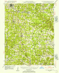 1945 Willow Springs1954 Print · USGSThis Howell County survey captured the Missouri Ozarks at mid-century, when the railroad still linked small farming towns. Researchers can trace rural school locations like College Hill Sch and cemeteries such as Lone Pine Cem and Rowe Cem.3 unique versions available
 - 1945 Map of Clear Springs, 1963 Print
 1945 Clear Springs1963 Print · USGSTexas County in the mid-1940s was a network of highland farms and timbered hollows at the headwaters of the Jacks Fork. Researchers can trace rural life through numerous country sites like Steely Chapel, Dutch Ch, and the Rocky Mtn Ranch.2 unique versions available
 - 1948 Map of Clear Springs
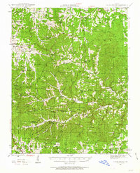
 1948 Clear Springs1948 Print · USGSTexas and Howell Counties in the mid-forties reveal a deeply dissected Ozark landscape of small farming communities and timbered hollows. Genealogists can trace family roots through numerous local landmarks like New Salem Cem, Grogan School, and Steely Chapel.2 unique versions available
 - 1948 Map of Willow Springs
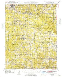 1948 Willow Springs1948 Print · USGSHowell County's post-war landscape comes alive through this mid-century survey of the Ozark Plateau. Researchers can trace family history through dozens of rural landmarks, from Sky Haven Airport and Trask to the Simms Valley Sch and Walkers Chapel.
 - 1949 Map of Rolla, 1950 Print
 1949 Rolla1950 Print · USGSThe Missouri Ozarks are captured here just after the war, showing a landscape of deep river valleys and emerging reservoir projects. Genealogists and historians can trace the mining towns of Bonne Terre and Potosi or follow the early route of U.S. Highway 66.
End of results
Showing maps 1-5 of 5
Top cities near Willow Springs
Frequently asked questions
- What are the different types of historical maps available for Willow Springs?
- What is the oldest map of Willow Springs?
- Where can I purchase historical maps of Willow Springs for my home or office?
- Where can I download high-res historical maps of Willow Springs?
- Are there historical topographic maps available for Willow Springs?
- Is there historical aerial imagery available for Willow Springs?
- Where are historical maps of Willow Springs sourced from?