1980s Maps of Willow Springs, Missouri
Explore 5 historic maps of Willow Springs from the 1980s. These maps offer a rare glimpse into what life looked like during the 1980s — showing old roads, neighborhoods, homes, and landmarks that have changed or disappeared over time.
Whether you're researching your family's past, planning a metal detecting trip, or studying how Willow Springs's landscape evolved across the 1980s, these high-resolution maps are a powerful tool for exploring the history of this region.
- Focus on a specific era: All maps on this page are from the 1980s, giving you a focused view of this time period.
- See what’s changed: Compare century-old streets, trails, and buildings to today's modern landscape using overlays and satellite layers.
- Research with precision: Use these maps for genealogy, historical research, land use analysis, or educational projects.
- View, download, or print: Maps are fully viewable online in high resolution, and can be downloaded or printed for your own records.
Start exploring Willow Springs's history through authentic maps from the 1980s. This is your window into the past.
Willow Springs, MO maps
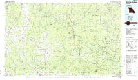
(5)- 1984 Map of West Plains
 1984 West Plains1984 Print · USGSThe Missouri Ozarks are mapped here in the mid-1980s, centered on the regional hub of West Plains and the river corridors of the Eleven Point River. Trace the old rail lines and timber towns of Willow Springs, Mountain View, and Birch Tree through the Mark Twain National Forest.2 unique versions available
 - 1986 Map of Spring Valley
 1986 Spring Valley1986 Print · USGSThe Missouri Ozarks are showcased in the mid-1980s, revealing a landscape defined by state forests and the protected waters of the Current River. Researchers can trace local heritage through landmarks like Oakside Ch, Fletcher Mine, and Summersville Cem.2 unique versions available
 - 1986 Map of Willow Springs South
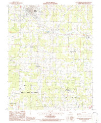 1986 Willow Springs South1986 Print · USGSHowell County's Ozark landscape is documented here in the mid-1980s, showcasing the expansion of Willow Springs into the surrounding timberlands. Researchers can find the old Iron Mine, the Drive-In Theatre, and the rural community of Burnham.
 - 1987 Map of Willow Springs North
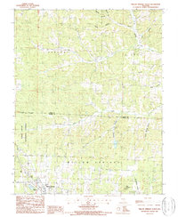 1987 Willow Springs North1987 Print · USGSWillow Springs and the surrounding Ozark foothills are captured here in the late eighties as the town borders the Mark Twain National Forest. Researchers can trace old family lands and water sources near South Prong Jacks Fork, King Mountain, and the Frisco Reservoir.2 unique versions available
 - 1989 Map of Rolla
 1989 Rolla1989 Print · USGSThe Missouri Ozarks are captured in the late eighties as a landscape of national forests and historic mining towns. Researchers can trace the rail lines of the Missouri Pacific RR or locate landmarks like Taum Sauk Mtn and Elephant Rocks State Park.
End of results
Showing maps 1-5 of 5
Top cities near Willow Springs
Frequently asked questions
- What are the different types of historical maps available for Willow Springs?
- What is the oldest map of Willow Springs?
- Where can I purchase historical maps of Willow Springs for my home or office?
- Where can I download high-res historical maps of Willow Springs?
- Are there historical topographic maps available for Willow Springs?
- Is there historical aerial imagery available for Willow Springs?
- Where are historical maps of Willow Springs sourced from?