1940s Maps of Ripley, Independence
Explore 2 historic maps of Ripley from the 1940s. These maps offer a rare glimpse into what life looked like during the 1940s — showing old roads, neighborhoods, homes, and landmarks that have changed or disappeared over time.
Whether you're researching your family's past, planning a metal detecting trip, or studying how Ripley's landscape evolved across the 1940s, these high-resolution maps are a powerful tool for exploring the history of this region.
- Focus on a specific era: All maps on this page are from the 1940s, giving you a focused view of this time period.
- See what’s changed: Compare century-old streets, trails, and buildings to today's modern landscape using overlays and satellite layers.
- Research with precision: Use these maps for genealogy, historical research, land use analysis, or educational projects.
- View, download, or print: Maps are fully viewable online in high resolution, and can be downloaded or printed for your own records.
Start exploring Ripley's history through authentic maps from the 1940s. This is your window into the past.
Ripley, Independence maps
(2)- 1945 Map of Missouri City, 1955 Print
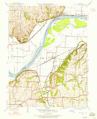 1945 Missouri City1955 Print · USGSMissouri City and the river bottomlands are captured here in the mid-1940s, showing a landscape defined by rail lines and rural school districts. Genealogists can trace family footprints at Blue Mills, New Salem Ch, and numerous country schools like Lynch Sch.
 - 1947 Map of Missouri City
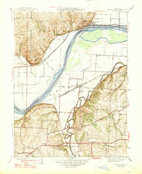 1947 Missouri City1947 Print · USGSThe Missouri River bottoms and surrounding bluffs appear here in the mid-1940s, showing a rural landscape defined by heavy rail and river crossings. Genealogists can locate family-named landmarks and institutions like New Salem Ch, Blue Mills, and the McCune Home.2 unique versions available
End of results
Showing maps 1-2 of 2
Top cities near Ripley
- Kansas City historical maps
- Independence historical maps
- Lee's Summit historical maps
- Blue Springs historical maps
- Liberty historical maps
- Raytown historical maps
See more
Frequently asked questions
- What are the different types of historical maps available for Ripley?
- What is the oldest map of Ripley?
- Where can I purchase historical maps of Ripley for my home or office?
- Where can I download high-res historical maps of Ripley?
- Are there historical topographic maps available for Ripley?
- Is there historical aerial imagery available for Ripley?
- Where are historical maps of Ripley sourced from?