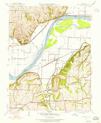
1945 Map of Missouri City
USGS Topo · Published 1955About this map
Missouri City sits prominently on the north bank of the Missouri River near the Missouri City Bend, a focal point for the region's river and rail economy mid-century. The landscape is defined by the convergence of major waterways, including the Little Blue River and Fishing River, with the Wabash and Santa Fe railroads carving paths through the bottomlands. This survey illustrates a dense network of rural infrastructure, from the industrial site at Blue Mills to an array of local institutions like Academy Sch and Sixmile Ch. The inclusion of Fort Osage on the eastern bluffs and the McCune Home further south provides significant anchor points for local historians. Topographical details such as Nebo Hill contrast with the level plains of Atherton, showing the varied terrain that influenced settlement and road placement along Kentucky Road and Atherton Road.
Find a feature on this map
43 named features on this map. Tap any name to fly to it.
Don’t see what you’re looking for? This feature index may not catch every label — zoom into the map to look around manually.
Map Details
Editions of this 1945 Missouri City Map
This is the sole edition of this map. No revisions or reprints were ever made.
Other maps of this area

1894 · Independence
USGS Topo · 1:125,000

1933 · Blue Springs
USGS Topo · 1:24,000

1934 · Oak Grove
USGS Topo · 1:24,000

1934 · Independence
USGS Topo · 1:24,000

1935 · Buckner
USGS Topo · 1:24,000

1935 · Missouri City
USGS Topo · 1:24,000

1935 · Liberty
USGS Topo · 1:24,000

1936 · Kearney
USGS Topo · 1:48,000

1940 · Liberty
USGS Topo · 1:31,680
1940 · Independence
USGS Topo · 1:31,680