1930s Maps of Imperial Township, Missouri
Explore 2 historic maps of Imperial Township from the 1930s. These maps offer a rare glimpse into what life looked like during the 1930s — showing old roads, neighborhoods, homes, and landmarks that have changed or disappeared over time.
Whether you're researching your family's past, planning a metal detecting trip, or studying how Imperial Township's landscape evolved across the 1930s, these high-resolution maps are a powerful tool for exploring the history of this region.
- Focus on a specific era: All maps on this page are from the 1930s, giving you a focused view of this time period.
- See what’s changed: Compare century-old streets, trails, and buildings to today's modern landscape using overlays and satellite layers.
- Research with precision: Use these maps for genealogy, historical research, land use analysis, or educational projects.
- View, download, or print: Maps are fully viewable online in high resolution, and can be downloaded or printed for your own records.
Start exploring Imperial Township's history through authentic maps from the 1930s. This is your window into the past.
Imperial Township, MO maps
(2)- 1930 Map of Pacific SE
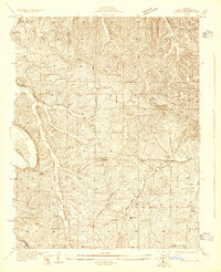 1930 Pacific SE1930 Print · USGSJefferson County rural life in the early 1930s is captured here through its network of country schoolhouses and river valleys. Researchers can trace historic routes like Le May Ferry Road and find old settlements such as Belews and Goldman.2 unique versions available
 - 1931 Map of Pacific NE
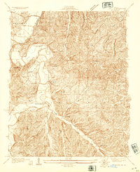 1931 Pacific NE1931 Print · USGSJefferson County was a land of river bends and rural schools in the early thirties. Local historians can trace the foundations of communities at Byrnes Mill and House Springs, or locate old schoolhouse sites like Whiteoak Sch and Cedar Sch.2 unique versions available
End of results
Showing maps 1-2 of 2
Top cities near Imperial Township
- Oakville historical maps
- Wildwood historical maps
- Ballwin historical maps
- Kirkwood historical maps
- Mehlville historical maps
- Webster Groves historical maps
See more
Top neighborhoods of Imperial Township
- Antonia historical maps
- Barnhart historical maps
- Seckman historical maps
- Spring Forest historical maps
- Otto historical maps
Frequently asked questions
- What are the different types of historical maps available for Imperial Township?
- What is the oldest map of Imperial Township?
- Where can I purchase historical maps of Imperial Township for my home or office?
- Where can I download high-res historical maps of Imperial Township?
- Are there historical topographic maps available for Imperial Township?
- Is there historical aerial imagery available for Imperial Township?
- Where are historical maps of Imperial Township sourced from?