
1930 Map of Pacific SE
USGS Topo · Published 1930About this map
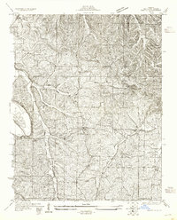
The Big River carves a winding path through the northern reaches of Jefferson County in this 1930 survey, reflecting a landscape defined by its waterways and ridge-line roads. This early topographic study highlights the rural infrastructure of the era, showing a network of small schoolhouses like Oak Hill Sch, Mt Olive Sch, and Highland Sch that served the local farming communities. Small settlements such as Belews and Goldman appear as quiet clusters of activity connected by historic thoroughfares, including the Le May Ferry Road and Hillsboro Road.
Find a feature on this map
27 named features on this map. Tap any name to fly to it.
Don’t see what you’re looking for? This feature index may not catch every label — zoom into the map to look around manually.
Map Details
Editions of this 1930 Pacific SE Map
2 editions found
Other maps of this area

1901 · De Soto
USGS Topo · 1:125,000

1912 · Kimmswick
USGS Topo · 1:62,500

1915 · Crystal City
USGS Topo · 1:62,500

1916 · Kimmswick
USGS Topo · 1:62,500

1930 · De Soto NE
USGS Topo · 1:24,000

1931 · Pacific NE
USGS Topo · 1:24,000

1937 · Pacific
USGS Topo · 1:24,000

1937 · Fletcher
USGS Topo · 1:24,000

1938 · Cedar Hill
USGS Topo · 1:24,000

1938 · Fletcher
USGS Topo · 1:24,000